Construction work is changing!
With a compact RTK surveying GPS device, point clouds and AR can be completed with just one device.
This article takes an average of 2 minutes and 30 seconds to read
Published March 14, 2025
The construction industry faces many challenges in surveying operations. Traditional surveying methods take time and effort for tasks like setting points and verifying the finished work, and the installation and operation of specialized equipment require advanced skills. For instance, GPS standalone positioning can result in errors of several meters, and precise surveying with a total station, including multiple trips to the site, was essential for accurate pile driving and design verification. In this context, the recently introduced compact RTK surveying GPS devices have the potential to revolutionize surveying tasks, enabling high-precision positioning, point cloud scanning, and even on-site visualization with AR—all in one device.
In this article, we will explain the latest trends and benefits of small surveying devices that utilize RTK technology, comparing them to traditional methods. Furthermore, we will introduce LRTK products that implement this technology, offering a glimpse into efficient surveying workflows for the construction DX era, along with a link to request free materials. We aim to provide valuable information for industry professionals based on keywords such as "RTK" and "surveying."
What is a Compact RTK Surveying GPS Device?
RTK (Real-Time Kinematic) surveying is a positioning technology that simultaneously conducts GNSS observations with a base station (fixed station) and a rover (mobile station) on the ground. Using correction data transmitted from the base station, the position of the rover is calculated in real-time with centimeter-level accuracy.
With RTK-GNSS, it is possible to reduce the usual GPS positioning error (typically a few meters) to within a few centimeters, allowing high-precision location information to be obtained instantly at the survey site. For more detailed information about "RTK surveying," please refer to our blog article, "What is RTK? The Basics of Real-Time Kinematic Positioning."
Traditionally, performing RTK surveying required a variety of equipment, including large GNSS receivers, setup tripods, external batteries, control controllers, and communication cables. Transporting and setting up all this equipment was time-consuming, and it was common for at least two skilled surveyors to be involved in the work. However, due to advances in miniaturization and improved performance of electronic components, products that integrate RTK surveying capabilities into a handheld device have recently emerged. For example, in China, a lightweight, compact, and highly sensitive "pocket RTK" device was introduced in 2020, enabling stable, high-precision positioning even in harsh environments. These compact RTK devices allow a single worker to easily operate them in combination with a smartphone, offering significantly better mobility compared to traditional stationary equipment.
The introduction of these compact RTK surveying GPS devices has significantly lowered the barriers to surveying in the field. Simply bringing the device to the site and powering it on allows for the immediate acquisition of high-precision location data. By utilizing network-based RTK services (such as VRS) or Japan's GPS enhancement service (QZSS CLAS*), correction data can be obtained without needing to set up a dedicated base station. This enables surveying to begin instantly, even in mountainous areas or infrastructure construction sites, making "high-precision positioning anytime, anywhere" a reality.
*CLAS (Centimeter-Level Augmentation Service): A positioning service that uses the augmentation signal broadcast by Japan's Quasi-Zenith Satellite System (QZSS). With a compatible receiver, RTK-level positioning can be achieved even without an internet connection.
As mentioned above, the miniaturization and simplification of RTK surveying GPS devices are breaking through the limitations of traditional technology. Next, let's explore the specific benefits brought by point cloud scanning and AR (Augmented Reality) capabilities, all of which can be realized with just this device.
Benefits of Point Cloud Scanning and AR Utilization
By using compact RTK surveying devices, it is possible not only to measure the location of points but also to capture the site's conditions as 3D point cloud data and to display design data on-site using AR (Augmented Reality). Below, we will explain the main benefits of these advanced applications: "Point Cloud Scanning" and "AR (Augmented Reality) Utilization."
Improved Surveying Efficiency and Cost Reduction
With the miniaturization of devices and the automation of measurement techniques, surveying efficiency has improved significantly. For example, using point cloud scanning with laser scanners or photogrammetry, it has been reported that data collection time can be reduced by up to 50% compared to traditional manual terrain surveying. Even in large-scale projects, millions of measurement points can be acquired at once, allowing for detailed surveys to be completed in a short amount of time.
As a result, labor costs are reduced, and the need for multiple surveys or site revisits is minimized, contributing to overall project cost savings. Additionally, when using AR for surveying, the time spent aligning the design model is significantly reduced. The high-precision RTK minimizes the misalignment of the model placement, eliminating the need to repeatedly perform complicated location marking tasks on-site.
Once the device is set up, real-time results can be immediately verified on-site, leading to a more efficient workflow.
Improved Accuracy and Data Quality
The increased positioning accuracy provided by RTK not only reduces numerical errors but also contributes to better data quality management. Tasks like precise alignment and leveling, which were traditionally dependent on manual labor, can now be automated using high-precision GNSS, reducing human error. The acquired point cloud data is simultaneously recorded with global coordinate system information, eliminating the need to manually combine or geo-reference (coordinate alignment) data after it has been captured.
As a result, the acquired 3D data can be immediately compared to design plans or CAD data, allowing for checks on construction errors and verification of the work's accuracy. The improved precision of the surveying data also makes it easier to use for quantity calculations and quality inspections, helping prevent delays in identifying errors or redoing work in later stages.
Intuitive On-Site Visualization with AR
The introduction of AR (Augmented Reality) technology on construction sites brings revolutionary visualization capabilities to construction work. By overlaying a 3D design model on the real-world landscape through the screen of a smartphone or tablet, the completed structure can be intuitively checked on-site.
For instance, by displaying the design model of a building or structure on-site via AR, there is no longer a need to imagine the completed project in one's head, allowing both the client and all site stakeholders to share the same vision of the final outcome.
This smoothens consensus-building among stakeholders, preventing costly rework caused by design mistakes or misunderstandings. Additionally, AR technology can improve safety during construction. By displaying the locations of buried pipes and cables in AR while performing excavation work, the risk of accidentally damaging them is minimized.
In this way, AR-driven on-site visualization has broad applications, from design verification and communication to construction prediction and safety management, powerfully supporting the DX (digital transformation) of the job site.
Introduction to LRTK Products
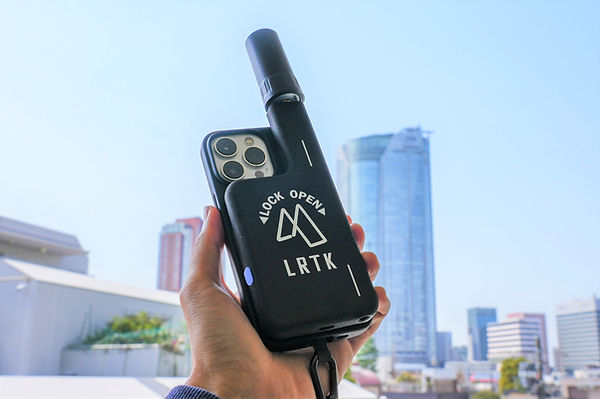
The innovative technology described above is brought to life in practical solutions through the LRTK products by Lefixea. LRTK is a product line developed as the pioneer of small RTK surveying GPS devices, offering a complete system that covers high-precision positioning, point cloud data acquisition, and AR-based model placement.
Features and Strengths of LRTK:
-
Compact All-in-One Device: LRTK is a lightweight, compact device that integrates an antenna, GNSS receiver, battery, and wireless module. It can be used with a dedicated pole or helmet, allowing for centimeter-precision surveying on-site without the need for large equipment. The robust design is built to withstand harsh conditions on construction sites, with dust and water resistance as additional features.
-
Instant Positioning and Tilt Correction: In addition to the network RTK system, LRTK is compatible with Japan's satellite positioning service CLAS, enabling high-precision positioning even in areas without internet coverage. The built-in IMU (Inertial Measurement Unit) offers tilt correction, allowing automatic adjustment of the measurement point coordinates even when the pole is tilted. This makes it especially useful for surveying in areas with obstacles or in narrow spaces while maintaining accuracy.
-
Smartphone Integration and Workflow Integration: LRTK devices work seamlessly with smartphones and tablets via Bluetooth or a dedicated app, allowing real-time use of positioning data. For instance, the smartphone can be used as a controller and data viewer to check the coordinates of points in real-time or to upload the data to the cloud for sharing with relevant parties. When combined with the smartphone's camera or LiDAR functionality, it becomes possible to attach positioning information to local photos or perform point cloud scanning, converting the data into 3D models in real-time. Surveying data can also be seamlessly integrated with core systems or BIM software via the cloud, ensuring smooth data transfer between the field and the office.
-
Product Lineup for Different Applications: The LRTK series offers a range of unique products, including the stationary "LRTK Pro2", the smartphone-compatible "LRTK Phone", and the helmet-mounted "LRTK Helmet". For example, LRTK Phone allows users to capture photos while simultaneously recording location data with centimeter precision. It is used in applications like concrete crack surveys and disaster site documentation. The LRTK Helmet enables workers to automatically measure their own trajectories by simply wearing the helmet, even when their hands are occupied with tasks. This flexible lineup allows for tailored solutions to various use cases and situations, adding to the appeal of LRTK products.
LRTK to dramatically improve surveying accuracy and work efficiency on site
The LRTK series achieves high-precision GNSS positioning in the fields of construction, civil engineering, and surveying, enabling significant reductions in work time and improvements in productivity. It is also compatible with i-Construction, promoted by the Ministry of Land, Infrastructure, Transport and Tourism, making it the perfect solution for promoting digitization in the construction industry.
For more details on LRTK, please check the following links:
-
What is LRTK | LRTK Official Site
-
LRTK Series | Device List Page
-
Case Studies | Examples of Use on Construction Sites
For questions about the product, quotes, or consultations on implementation, feel free to contact us using the inquiry form below. Let's take your site to the next stage with LRTK!