Turn your smartphone into a high-precision, all-purpose surveying tool.
LRTK Phone
CLAS Compatible

Simple, One-Handed Positioning
Easily perform positioning by attaching the LRTK Phone to your smartphone.
Battery and antenna—all in the palm of your hand.

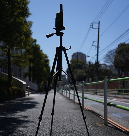
Fixed-Point Positioning with the Starter Kit
You can perform fixed-point positioning by attaching the LRTK Phone to a tripod.
Positioning accuracy is centimeter-level.
60m先までスキャン
国土交通省の出来型管理要領に準拠
誰でも簡単に絶対座標付き点群を作成
You can perform fixed-point positioning by attaching the LRTK Phone to a tripod.
Positioning accuracy is centimeter-level.

You can perform fixed-point positioning by attaching the LRTK Phone to a tripod.
Positioning accuracy is centimeter-level.


You can perform fixed-point positioning by attaching the LRTK Phone to a tripod.
Positioning accuracy is centimeter-level.
You can perform fixed-point positioning by attaching the LRTK Phone to a tripod.
Positioning accuracy is centimeter-level.

設計図と現況点群の差分を管理
You can perform fixed-point positioning by attaching the LRTK Phone to a tripod.
Positioning accuracy is centimeter-level.
You can perform fixed-point positioning by attaching the LRTK Phone to a tripod.
Positioning accuracy is centimeter-level.

You can perform fixed-point positioning by attaching the LRTK Phone to a tripod.
Positioning accuracy is centimeter-level.

歩いてもずれないAR
You can perform fixed-point positioning by attaching the LRTK Phone to a tripod.
Positioning accuracy is centimeter-level.


You can perform fixed-point positioning by attaching the LRTK Phone to a tripod.
Positioning accuracy is centimeter-level.
You can perform fixed-point positioning by attaching the LRTK Phone to a tripod.
Positioning accuracy is centimeter-level.


設計図と現況点群を比較
出来形ヒートマップを作成
You can perform fixed-point positioning by attaching the LRTK Phone to a tripod.
Positioning accuracy is centimeter-level.
現場で即土量計算
You can perform fixed-point positioning by attaching the LRTK Phone to a tripod.
Positioning accuracy is centimeter-level.
.png)

杭打ち座標までcm精度で誘導
You can perform fixed-point positioning by attaching the LRTK Phone to a tripod.
Positioning accuracy is centimeter-level.

You can perform fixed-point positioning by attaching the LRTK Phone to a tripod.
Positioning accuracy is centimeter-level.

アンテナを変えるだけで圏外にも対応
通常のRTK-GNSS端末はインターネット環境でのみご利用いただけますが、LRTKは3周波対応。
みちびきからの補正情報を利用して圏外での測位が可能です。

圏外対応LRTKアンテナ
CLAS対応で、携帯電波の入らない場所でも使えます。もちろん、ネットワーク型RTKも利用できます。
万能測量機 LRTK Phone
LRTKの機能はまだまだあります。
ライセンスを持たない相手に
データを共有・閲覧いただく機能や、
図面をマップに重ねる機能。
点群の断面を図面に出力する機能。
屋内測位や被写体測位、
数えきれない機能があります。
どれか一つでもご興味がある場合には、
ぜひお気軽にお問い合わせください。

【相性のいい製品】大規模現場の
点群生成、処理、計測、共有
までこれ1つ LRTK ドローン
LRTK ドローンでは大規模点群を生成。
LRTK Phone でとりきれない
大規模現場をカバーします。

ドローン点群を取得する際
死角となる木陰を
Phoneの点群が補完します。


高スペックPC不要
別途のビューア購入も不要
全ての作業はノートPCで完結します。
専用ビューアを買う必要もありません。

悩む必要は0。
ソフトはこれ1つでドローン測量
と��点群活用が始められます。
All You Need is Your Smartphone
バッテリー内蔵でアンテナも付属。
位置補正情報も付属しています。
専用アプリをインストールするだけで、
設定不要ですぐに測位を始められます。

LRTK Pro2 Details
