Attention Small and Medium-Sized Construction Companies!
Achieve Low-Cost, High-Precision Surveying with RTK Devices Equipped with LRTK Technology
This article takes an average of 2 minutes and 30 seconds to read
Published March 14, 2025
Surveying tasks on construction sites require both manpower and time, while also demanding high precision. However, for small and medium-sized construction companies, it is often difficult to equip themselves with specialized surveying technicians or expensive equipment, creating significant challenges due to labor shortages and cost burdens. Traditional GPS positioning results in errors of several meters, but with RTK (Real-Time Kinematic) positioning, positioning accuracy can be improved to within a few centimeters, offering much higher precision.
Given this background, there is increasing attention on new technologies that can achieve high-precision and efficient surveying. One such technology is the RTK surveying device equipped with LRTK technology, which is considered easy to adopt even by small and medium-sized enterprises. Thanks to LRTK technology, the barriers of specialized knowledge and high costs that have traditionally hindered the use of RTK surveying can now be overcome, offering a new opportunity for easier implementation.
What is LRTK Technology?
RTK surveying is a positioning method in which correction data from a reference station, installed at a known point, is sent to a moving station to calculate high-precision positions in real-time. While standalone positioning (regular GPS surveying) typically results in errors of several tens of meters, RTK improves accuracy to within a few centimeters.
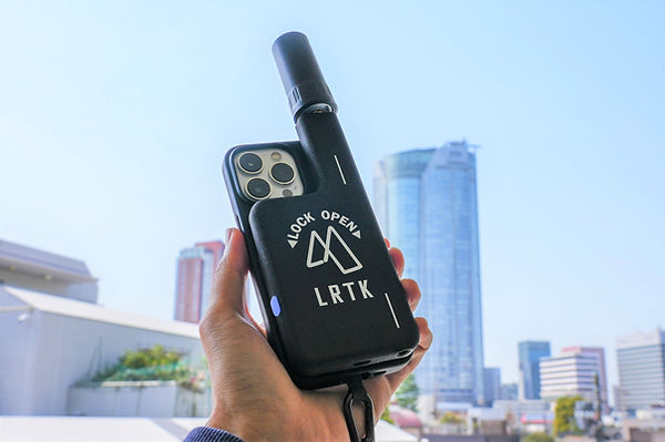
LRTK technology is a more user-friendly version of this high-precision positioning technology. LRTK is a digital positioning technology provided by Refexia Inc., a startup originating from the Tokyo Institute of Technology. It combines dedicated devices and smartphone apps to make RTK surveying easily accessible.
The greatest feature of LRTK technology is its ease of use and low implementation threshold, making it ideal for small and medium-sized construction companies. Traditional RTK surveying equipment required specialized technicians for setup, but with LRTK, anyone can easily perform centimeter-level surveying by simply attaching an ultra-compact RTK-GNSS receiver to a smartphone or tablet.
For example, with a device called the LRTK Phone, you can simply attach the device to an iPhone or iPad, launch the dedicated app, and instantly transform your smartphone into a pocket-sized all-in-one surveying tool. The positioning results are provided in global coordinates, and the data is instantly shared on the cloud, allowing for real-time information sharing between the site and the office.
Additionally, LRTK technology excels in flexibility compared to other surveying technologies. For example, it supports the centimeter-level augmentation service (CLAS) provided by Japan's quasi-zenith satellite system, Michibiki, enabling RTK positioning to continue even in areas where internet communication is unavailable, such as mountainous regions or disaster sites, by receiving correction data directly from satellites. In this way, LRTK is a new RTK surveying solution that combines advanced GNSS technology with a focus on ease of use for the field.
Benefits of Introducing LRTK Technology
By introducing LRTK technology, you can simultaneously achieve both cost reduction and high precision in surveying tasks. Let’s look at some specific benefits:
-
Ease of Use without the Need for Specialized Knowledge: LRTK surveying devices can be operated with an intuitive smartphone app. Without needing to worry about complex equipment settings or surveying calculations, positioning can be started and data saved with just the press of a button. For example, with the LRTK Phone, simply attach the receiver to an iPhone, launch the app, and press a button at the desired point to acquire coordinates. With features such as automatic point name assignment and memo functionality, the design is thoughtful and user-friendly, making it easy for anyone—regardless of whether they are a surveying specialist—to use the device effectively.
-
Significant Cost Reduction in Surveying: Traditionally, investments of several hundred thousand yen were required for total stations or high-end GNSS equipment, but the LRTK device offers an overwhelmingly lower price. It has been described as "extremely affordable. Having one device per person would significantly improve productivity on-site," with some cases showing initial investment costs reduced to less than a fifth of traditional equipment. Moreover, since surveying can be done by a single person, labor costs are reduced, further lowering overall operational costs.
-
Shortening and Streamlining Surveying Time: LRTK technology also enhances the speed of the surveying process itself. Traditionally, a team of two was needed for total station point observations, but with LRTK, a single person can complete an observation in just about 10 seconds per point. The device also has a continuous positioning feature, allowing up to 10 points per second to be recorded, dramatically reducing surveying time even for large-scale terrain surveys. As measurement data is automatically calculated and recorded, the need for post-processing is reduced, leading to an overall improvement in work efficiency.
-
Ease of Immediate Implementation: LRTK products are compact, lightweight, and easy to carry. With a size that fits in your pocket, it’s realistic for each on-site worker to carry one device. To make it easy for small to medium-sized companies to adopt, subscription-based monthly plans are available to reduce initial costs. This makes it easy to try out the device without worrying about "not being able to use it effectively" or "it becoming a wasted investment." You can use it as needed, only when required.
As outlined above, LRTK technology offers significant advantages for small to medium-sized construction companies in terms of ease of use, cost savings, and operational efficiency. Now, let’s compare how it differs from traditional surveying methods.
Use Cases of LRTK Technology
By implementing LRTK technology, let's look at some examples of how it has been effective in actual construction sites and infrastructure maintenance.
Use Case in Small-Scale Construction Sites
Even in small-scale construction sites with limited manpower, LRTK surveying devices allow a single worker to handle site measurements and as-built measurements. For example, in cases where foundation layout was traditionally outsourced to surveyors, in-house workers can now perform the layout using the LRTK device. Information collected by the worker on-site can be instantly uploaded to the cloud, allowing office technicians to review and issue instructions immediately.
This reduces wasted time from issues like "realizing a measurement mistake and having to redo it," enabling construction to proceed while managing quality in real-time. In fact, after adopting LRTK, a construction company reported that even less experienced staff could complete layout tasks accurately, reducing reliance on outsourced surveying and achieving cost savings while bringing surveying expertise in-house.
Use Cases in Infrastructure Maintenance and Disaster Sites
LRTK technology is also proving highly effective in infrastructure inspections and disaster surveys. For example, in concrete structure crack inspections, location coordinates with centimeter-level precision are automatically tagged to photos taken with a smartphone, and the data is stored in the cloud for records.
This enables precise location tracking and management of infrastructure deterioration points that are difficult to identify with photos alone. In addition, during the 2023 Noto Peninsula earthquake, LRTK devices played a vital role in the disaster site, where large equipment could not be brought in and communication infrastructure was cut off. Because the LRTK device can maintain high-precision positioning using augmentation signals from Michibiki satellites, it was possible to quickly record and share location data of damaged areas. A person in charge stated, "With just one small LRTK device, it was highly effective for sharing on-site disaster conditions," demonstrating its usefulness as an agile surveying tool in emergencies.
Furthermore, there is also the unique use case of the LRTK Helmet. This involves attaching an RTK receiver with a thin antenna to a worker's helmet, allowing for continuous high-precision positioning just by walking.
Even when both hands are occupied with tasks, it allows the worker’s movement trajectory to be recorded, enabling the collection of surveying data for the path walked during large-scale infrastructure inspections. For example, in inspections of long bridges or tunnels, visualizing the movement trajectory of workers allows for detailed analysis of the location of abnormal areas afterward. The recorded coordinate data is instantly transmitted to the cloud via the smartphone, allowing remote supervisors to track progress and measurement results in real-time.
Success Stories in Terrain Surveying and As-Built Management
LRTK technology is also highly effective in terrain surveying and as-built management in civil engineering projects. Traditionally, verifying the as-built condition (such as the shape of fill or excavation) at a construction site required measuring many points and creating cross-sectional drawings, which was labor-intensive. With the LRTK device, workers can walk around the site and continuously measure, collecting data on the land's topography in a comprehensive manner.
For example, by simply walking around the site, an operator can collect elevation data at a high density, up to 10 points per second, quickly capturing the 3D shape of the entire site.
At one site, the as-built surveying, which previously took half a day, was completed in just about one hour after introducing the LRTK device. The number of measurement points increased dramatically, enabling highly accurate quantity calculations. Furthermore, since the data can be instantly shared, the project manager and client can review the results on-site, enabling inspections without rework.
Introduction to LRTK Products
The surveying devices equipped with LRTK technology come in a variety of models tailored to meet on-site needs. Each model features unique characteristics not found in competing products and is designed to be easily adopted and utilized by small and medium-sized construction companies. Here, we will introduce the representative LRTK products and their features.
This allows for point surveying even in situations where the pole cannot be set vertically due to trees or obstacles. The LRTK Pro2 connects via Bluetooth with smartphones or tablets, enabling immediate surveying via the app, so there is no need for the complex setup required by traditional GNSS devices. Compared to competing high-precision GNSS equipment, the LRTK Pro2 stands out with its advantages, such as the ability to operate independently through CLAS support and the improved work efficiency provided by its tilt correction feature.
In addition, there are models designed for specific applications, such as the LRTK Helmet, which focuses on tracking the movements of workers. All of these products share the common concept of being designed to make surveying more accessible and usable by anyone. Traditionally, surveying equipment was considered a tool for experts, but LRTK products are designed to be practical devices that can be used daily by on-site workers and construction managers.
As a result, this not only improves the precision of surveying but also enhances the efficiency of daily construction management and inspection tasks.
Dramatically Improving Surveying Accuracy and Work Efficiency on Site with LRTK
The LRTK series enables high-precision GNSS positioning in the construction, civil engineering, and surveying fields, allowing for significant reductions in work time and substantial improvements in productivity. It also supports i-Construction, a project promoted by the Ministry of Land, Infrastructure, Transport and Tourism, making it the ideal solution for promoting digitalization in the construction industry.
For more details about LRTK, please visit the links below:
If you have any questions about our products, quotes, or inquiries regarding implementation, feel free to contact us via the inquiry form below. Let LRTK help take your site to the next stage of evolution.