Revolutionizing RTK Surveying:
Small GPS Devices with LRTK Technology Are Changing Construction Sites
This article takes an average of 2 minutes and 30 seconds to read
Published March 14, 2025
In construction and civil engineering sites, RTK surveying (Real-Time Kinematic positioning), which allows for real-time high-precision positioning, is essential. However, traditional RTK surveying equipment has had several challenges. First, the equipment was bulky, with base station GNSS receivers, rover receivers, communication modems, and dedicated poles or tripods, making it cumbersome to transport. It wasn't until recently that lightweight and compact receivers, small enough to be mounted on a helmet, were introduced. In the past, simply carrying the positioning equipment was already a burden on the site.
Additionally, high-precision positioning requires a communication environment with the base station, making RTK surveying difficult in areas with no mobile signal, such as mountainous regions. In sites without internet connectivity, there were limitations to improving precision. However, with the advent of technology that utilizes Japan's Quasi-Zenith Satellite System (QZSS) CLAS signals, centimeter-level positioning can now be achieved even in off-network environments.
Furthermore, in environments where GNSS signals are obstructed, such as in forests or under overpasses, obtaining RTK Fix (integer phase resolution) has been challenging. There has been an increasing demand for receivers capable of achieving centimeter-level accuracy in these areas.
Meanwhile, in recent years, the ability to easily perform 3D point cloud surveying with LiDAR scanners mounted on devices such as iPhones and iPads has gained attention. However, when using a standard smartphone for point cloud measurement, the obtained data lacks absolute coordinates, and when walking around to scan, the terrain can become distorted. The use of augmented reality (AR) for positioning also faced limitations, as the device's position estimation accuracy was restricted, causing virtual objects to shift slightly when moving.
These technological limitations led to the need for multiple pieces of equipment for different purposes, such as devices for point cloud scanning or positioning systems for AR. Additionally, RTK surveying equipment is expensive and requires specialized knowledge, meaning that only a limited number of surveying technicians could operate it, making it difficult to equip each worker with a device on-site.
To address these challenges in RTK surveying, the LRTK Phone, a compact, high-precision GPS device with LRTK technology, was developed. This groundbreaking device, which can integrate with smartphones, marks a significant turning point in RTK surveying.
Features of LRTK Technology: Compact, Lightweight, Fast FIX, All-in-One
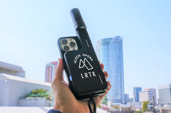
This is how the LRTK Phone device is attached to an iPhone. The 125g receiver, which fits in your pocket, transforms your smartphone into a "universal surveying machine" with centimeter-level positioning. From coordinate guidance to point cloud scanning and photo measurements, this one device is designed to handle a wide range of tasks.
The LRTK Phone, equipped with LRTK technology, offers attractive features that defy conventional expectations. Its major strengths include: "compact size and excellent portability," "instant positioning with high-speed FIX," and "all-in-one functionality that handles point cloud scanning, AR, and photo measurements." Let's take a closer look at each of these strengths.
-
Compact and Lightweight with Excellent Portability: The LRTK Phone is a compact receiver that fits in your pocket, weighing just around 125g and measuring about 13mm in thickness. It attaches effortlessly to the back of your smartphone and is designed to fit into one hand, including the battery and antenna. Unlike traditional methods, there’s no need to carry a tripod or pole, and it doesn’t get in the way while moving around the site. Since the device is always with the worker and can be used immediately when needed, it is the perfect positioning device for "one device per person."
-
Instant Centimeter-Level Positioning with High-Speed FIX: With LRTK technology, the time required for initialization (Fix resolution) is drastically reduced, allowing for centimeter-level positioning to start within seconds after powering on the device at the site. This is due to the high-performance GNSS receiver, which supports multi-GNSS and three frequencies, combined with the latest algorithms. Additionally, it supports Japan’s QZSS satellite’s centimeter-level correction service (CLAS), enabling high-precision RTK positioning even in areas without mobile network coverage, such as mountainous regions or near tunnels. Unlike previous systems, which struggled to maintain accuracy when communications were interrupted, LRTK can continue to provide stable positioning and quickly achieve Fix, maintaining precision even in forests or city building shadows. This immediate positioning and high reliability significantly reduce waiting time for surveying tasks.
-
All-in-One Multi-functionality: The LRTK Phone covers all the necessary functions for field surveying. In addition to single-point coordinate measurement (observation) and leveling, it can be combined with the smartphone's LiDAR to perform high-precision point cloud scanning with coordinates, and instantly calculate distances, areas, and volumes from the data. Moreover, it also allows for marking (positioning) and coordinate guidance using positioning data, with functions such as guiding to design points using arrows or marking virtual stakes on-site via AR display. Additionally, when taking photos, the device records the location coordinates and orientation, which can be compared with previous photos on the cloud, aiding in infrastructure inspection and tracking the progression of changes over time. The ability to perform positioning, point cloud scanning, AR, and photo documentation with a single device is the core strength of the LRTK technology-enabled device.
Examples of Use in the Construction Industry: From Civil Engineering to Infrastructure Maintenance
The LRTK Phone, with its compact and high-performance design, can be utilized in a wide range of scenes within the construction industry. From large-scale projects at major construction companies to fieldwork at small and medium-sized civil engineering firms, and even to the maintenance of infrastructure such as railways and highways, let’s take a look at the specific benefits it brings to the site.
Surveying and Marking in Civil Engineering and Construction Sites
In civil engineering and construction sites, RTK surveying is widely used for benchmark surveying and marking the position for piling (marking work). With the LRTK terminal, a single worker can easily complete high-precision surveying and marking tasks. Traditionally, one surveyor would carry a pole with the receiver, while another person would operate the controller.
However, with the LRTK integrated with a smartphone, a single worker can handle everything from measuring points to marking. For example, when determining the position of a structure, the worker can simply follow the AR arrow showing coordinates on the smartphone screen, walking to the specified position, and be notified by vibration or sound once they reach the destination, ensuring accurate point identification without any confusion. Even staff with limited surveying experience can intuitively use it, meaning that surveying work won’t stop even when experienced personnel are unavailable. Furthermore, with the AR function of the LRTK, virtual markers or piles can be projected onto the designated position. In dangerous slopes where access is difficult or places where the ground is hard and piling is challenging, positioning the target coordinates from a safe distance and setting up a virtual pile on the AR system allows for remote positioning. In this way, the LRTK technology greatly enhances the efficiency and safety of surveying and marking tasks at the site.
Application in Infrastructure Inspections and Maintenance
LRTK technology also proves invaluable in the regular inspection of infrastructure equipment such as roads and railways. For example, during crack inspections of tunnels and bridges, it is essential to take photos from the same location and angle to compare changes over time. With LRTK Phone, the coordinates of the shooting location and camera orientation (azimuth) can be recorded, making it easy for anyone to take photos with the same composition as the previous ones. The dedicated app’s AR display guides the orientation of the previously taken images, so there's no risk of forgetting "where and in what direction the photo was taken." The photos are immediately uploaded to the cloud, and by comparing them with past images, it is easy to detect the progression of cracks and damage.
This eliminates the need to search through old photos from paper logs and compare them, centralizing the management of infrastructure inspection records digitally.
Additionally, during the routine inspection of railways and highways, large areas need to be checked in a short amount of time. However, with LRTK, each worker can carry it and instantly share location-tagged photos or notes on the cloud.
If abnormalities are noticed on-site, the coordinates of the affected areas can be measured on-site and sent along with the photos, allowing office staff to quickly assess the situation and issue instructions. This smoothens the coordination between the site and office, leading to quicker and more accurate responses. High-precision location-tagged data is expected to become the foundation for future maintenance digital transformation (DX), contributing to the efficient and prolonged lifespan of infrastructure assets.
Streamlining Point Cloud Scanning and As-Built Management
Another strength of LRTK Phone is its ability to revolutionize 3D scanning and as-built management on-site. By combining the built-in LiDAR scanner of iPhone/iPad with LRTK, anyone can easily obtain coordinate-tagged point cloud data without the need for special equipment.
For instance, when measuring the volume of fill and excavation occurring daily at construction sites, traditionally, laser scanners or drones were used to collect data, and the data was then analyzed in the office. After the introduction of LRTK, a worker can now scan and measure the soil volume right on-site with just a smartphone taken from their pocket.
The acquired point cloud data allows instant calculations of distances between two points, enclosed areas, and volumes, significantly reducing the time required for daily as-built management and quantity checks. There's no need to bring heavy surveying equipment or specialized PCs to the site, and the ability to acquire and analyze data without leaving the site boosts construction management productivity.
Furthermore, point cloud data and photos obtained via LRTK are automatically synchronized with the cloud. It is easy to overlay and compare the latest terrain data scanned on-site with the design’s 3D model in the cloud. For example, you can align the construction plan model with the current point cloud to calculate the difference in soil volume and instantly estimate the required amount of material for delivery.
Previously, time-consuming soil volume calculations would be completed in the office; now, these tasks can be completed in real-time on-site, contributing to reduced project timelines and cost savings. LRTK seamlessly connects the site with the cloud, serving as a comprehensive tool to support the digitalization and efficiency of construction operations.
Cost-Effectiveness and Usability for Small and Medium Enterprises
While the latest surveying technology may seem expensive, the LRTK Phone stands out for its affordable price and low barriers to entry.
In fact, it has been said that "having one unit per person would significantly improve on-site productivity," and since there's no need to limit the number of units due to cost considerations, it is easy for a wide range of companies, from large general contractors to small civil engineering firms, to adopt. In the past, on-site workers would have to share limited surveying equipment within the team, but now each worker can carry their own high-precision positioning device.
As a result, workers can immediately perform surveying and measurements when needed, directly reducing wait times and preventing errors. For example, even a small construction company can reduce outsourcing costs and shorten timelines by implementing LRTK, allowing site managers and foremen to conduct surveys on their own. The device is easy to use, with no special skills required, and because it primarily relies on smartphone apps, even less experienced workers can immediately use it on-site. This is a significant advantage for the construction industry, where labor shortages are a major challenge. LRTK technology, which can be described as the "democratization of high-precision positioning," is expected to boost the overall productivity and competitiveness of the industry.
Dramatically Improve Surveying Accuracy and Work Efficiency on Site with LRTK
The LRTK series enables high-precision GNSS positioning in the fields of construction, civil engineering, and surveying, allowing for significant reductions in work time and major improvements in productivity. It is also compatible with i-Construction, a program promoted by the Ministry of Land, Infrastructure, Transport, and Tourism, making it the ideal solution for advancing digitalization in the construction industry.
For more details on LRTK, please visit the following links:
-
What is LRTK | Official LRTK Website
-
LRTK Series | Device List Page
-
Case Studies | Examples of Use on Construction Sites
For any inquiries about the product, quotes, or consultations regarding implementation, feel free to contact us through the inquiry form below. Let LRTK help take your site to the next level.