LRTK High-Precision GPS Device Implementation Guide:
How to Utilize it on Civil Engineering Sites
This article takes an average of 2 minutes and 30 seconds to read
Published March 13, 2025
Recently, a high-precision GPS device called LRTK has gained attention for its ability to easily achieve centimeter-level high-precision positioning in civil engineering and construction surveying and construction management. Traditionally, high-precision positioning required specialized surveying equipment and advanced technology, but with LRTK, anyone can easily perform it with a smartphone.
This article explains the basics of the LRTK high-precision GPS device and its use on civil engineering sites, targeting general contractors, small to medium-sized civil engineering companies, surveying technicians, and infrastructure maintenance personnel. We will introduce the mechanism and specifications of LRTK, the benefits of using it on-site, preparation for implementation, specific usage instructions, and operational considerations. Finally, we provide information on how to request materials for free. If you are considering introducing high-precision GNSS devices, this guide will be a helpful reference.
1. Overview of LRTK (Mechanism and Specifications)
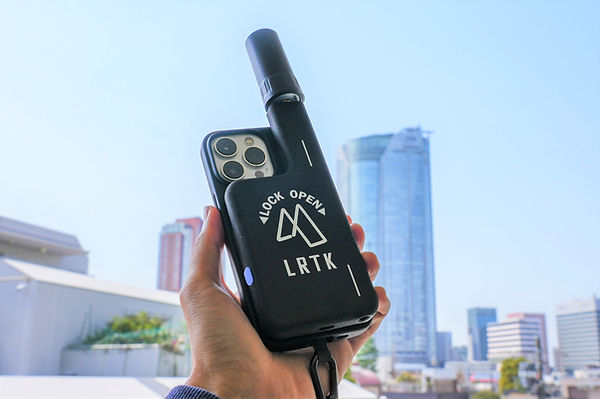
LRTK is a pocket-sized high-precision GNSS positioning device developed by our company. Designed to be integrated with a smartphone, it aims to create a "one device per person" surveying tool that can always be carried around, with practical usability that allows for immediate use when needed. By connecting via Bluetooth through the dedicated smartphone app "LRTK," the smartphone quickly transforms into a versatile surveying instrument with centimeter-level accuracy.
Mechanism:
The key to LRTK’s centimeter-level positioning is the RTK (Real-Time Kinematic) method. RTK involves using a reference station (base station) placed at a known location and a mobile station (rover) to simultaneously receive GNSS satellite signals, correcting common errors to improve positioning accuracy. While standalone GPS positioning can have errors of several meters, RTK eliminates these errors by performing relative positioning with the reference station, achieving high precision of ±1-2cm horizontally and ±3cm vertically. LRTK brings this RTK technology into a palm-sized device, providing accuracy that sets it apart from typical smartphone-integrated GPS.
Specifications:
LRTK is equipped with a high-performance receiver that supports multi-GNSS, receiving signals not only from GPS, but also from GLONASS, Galileo, and Japan’s quasi-zenith satellite system (Michibiki: QZSS). Particularly, it supports the centimeter-level augmentation service (CLAS) provided by Michibiki, allowing for high-precision positioning even in mountainous areas or places without internet access, by directly receiving correction data from satellites.
This capability is made possible because the LRTK terminal supports multiple frequencies such as L1/L2/L5 and performs advanced positioning calculations, providing a significant advantage by allowing real-time centimeter-level positioning even outside the smartphone’s signal range in outdoor environments. The positioning accuracy is approximately ±2cm for horizontal positions and ±3cm for vertical positions (depending on the environment), offering professional-grade surveying accuracy comparable to traditional stationary RTK equipment on-site.
2. Benefits of Using LRTK on Civil Engineering Sites
By introducing the LRTK high-precision GPS device on civil engineering and construction sites, various benefits can be gained in traditional surveying and construction management.
-
Improved Surveying Accuracy and Immediacy:
By obtaining position coordinates with centimeter-level accuracy, the time and effort required for setting reference points and leveling are significantly reduced. Traditional high-precision positioning, which was performed by surveying teams using total stations or expensive GNSS equipment, can now be executed instantly by anyone, enabling on-site as-built management and real-time comparison with design values. For example, by using LRTK, the accuracy of smartphone GPS, which previously had an error of several meters, can be improved to approximately ±2cm, allowing surveying results to be obtained instantly on-site. -
Improved Work Efficiency and Productivity:
LRTK is compact, lightweight, and highly portable, allowing each worker on-site to carry their own dedicated surveying device. This eliminates "waiting time," enabling surveying to be done immediately when needed, and allows multiple workers to perform surveying tasks concurrently. For example, in the past, one GNSS device was shared by an entire team, leading to waiting in line. However, when each worker carries their own LRTK and can measure independently, productivity across the entire site improves dramatically. Additionally, since the device is small enough to fit in a pocket, it is easy to carry around on-site, making it convenient to access high or narrow survey points. -
Cost Reduction and Lowered Barriers to Adoption:
Traditional high-precision GNSS equipment and surveying instruments were expensive and required specialized knowledge, but LRTK is offered at a relatively affordable price. Since it is designed to be used with a smartphone, there is no need to prepare multiple dedicated devices; you can simply utilize the smartphone you already have. The software is also intuitive, with an app that can be easily operated even by those who are not surveying experts, making it easy for small and medium-sized civil engineering companies to adopt. Furthermore, subscription plans that include cloud services are available, allowing you to start with reduced initial costs. -
Promoting Digitalization and Information Sharing:
LRTK integrates with a dedicated cloud service, allowing the coordinates and photos of the points collected to be instantly plotted on a map in the cloud and shared. The data measured on-site can be uploaded with a single tap from the smartphone, and staff in the office or partner companies can immediately view and download it via a web browser. This eliminates the need for traditional cumbersome tasks, such as recording data by hand on paper drawings and bringing them back to the office, and enables real-time information sharing and backup. For example, when photographing a crack in a bridge during an infrastructure inspection, the record with accurate coordinates and orientation is saved to the cloud on-site, allowing all stakeholders to precisely understand the location later. This greatly contributes to the efficiency of maintenance and report creation. -
Strengths in Harsh Environments and During Disasters:
LRTK is highly effective even in locations where mobile signals are unavailable, such as in mountainous dam construction sites or around mountain tunnels on highways. As mentioned earlier, the LRTK device supports Michibiki's CLAS, and since correction data can be obtained via satellites even outside of mobile network coverage, centimeter-level positioning is possible in offline environments. In fact, during the 2023 Noto Peninsula earthquake, LRTK was instrumental in the disaster area, contributing to the recording and sharing of damage conditions with high-precision location information. In disaster response scenarios, large equipment is often difficult to bring in, but with the compact LRTK device, on-site conditions can be quickly assessed and shared. This ability to perform positioning independent of communication infrastructure is a significant reassurance for infrastructure inspection and disaster prevention personnel.
As mentioned above, the introduction of LRTK brings benefits in terms of "accuracy," "efficiency," "digitalization," and "reliability." In the promotion of DX (Digital Transformation) on civil engineering sites and efforts related to i-Construction, it is expected to be a tool that dramatically improves the efficiency of data collection from the field.
3. Preparation for Implementation (Necessary Equipment and Environment)
To effectively use the LRTK high-precision GPS device on a civil engineering site, the following preparations and environmental setup are required in advance.
-
Necessary Equipment Preparation:
The essential equipment to begin with is the LRTK device itself. Obtain the LRTK Phone (smartphone-mounted device) provided by Lefixea Inc. Additionally, prepare the smartphone to be used. It is primarily designed for use with the latest iPhone series, but it can also be used with Android devices through Bluetooth connectivity (note that the physical smartphone case is designed for iPhone, so for Android devices, the terminal must be mounted on a pole or similar). Apart from the smartphone, it is helpful to have a monopod or tripod, or a pole to stabilize the device on-site. An optional dedicated monopod (a device that allows the terminal to be mounted on the pole’s tip) is also available. Using these tools will help stabilize the device at survey points, making it easier to obtain accurate positioning. Additionally, for long-term use, be sure to prepare backup power sources such as mobile batteries and chargers (the LRTK terminal is powered by an internal battery, but checking the continuous use time and having a backup power source is important). -
Installation of the Dedicated App:
Install the dedicated app "LRTK App" provided by Lefixea Inc. on the smartphone. It is available through the App Store (iOS). The app is available in Japanese and includes features such as start/stop positioning buttons, point recording, photo taking, continuous positioning, and cloud synchronization. Install the app in advance, and during the first startup, complete the registration and basic setup (creating an account, logging into the cloud service, etc.). -
Setting up Communication and Correction Data:
To perform high-precision positioning with LRTK, obtaining GNSS correction data (RTK correction data) is essential. In Japan, there are two main methods of obtaining correction data for using LRTK: via the internet or via Michibiki (QZSS). In urban areas or sites within mobile network coverage, the correction data can be obtained by connecting to private RTK correction services or the electronic reference point network (such as VRS services) via the mobile network. In remote areas, such as mountains or isolated islands, the LRTK terminal directly receives correction data via the Michibiki (QZSS) CLAS signal. The LRTK Phone 4C "Out-of-Range Model" allows for automatic switching to receive CLAS without special operation, enabling high-precision positioning even in areas without mobile signal. When implementing the system, make sure to confirm the method of correction data acquisition according to your usage scenario, and complete necessary procedures (e.g., registering for VRS services or configuring the terminal). When using CLAS, be aware that while the service is free, it is limited to Japan (generally within the range of latitudes and longitudes from Hokkaido to Okinawa). -
Confirming Operating Environment:
To maximize the use of LRTK, it is important that the environment is suitable for GNSS signal reception. Choose a location for positioning that is as open as possible and avoid places with obstructions overhead (e.g., under overpasses, in dense forests, or in valleys between buildings). Since GNSS satellites are plentiful overhead, the more open the environment (with a 360-degree view), the easier it is to perform positioning. However, construction sites often have obstacles, so if necessary, move the positioning point slightly, or measure in a direction where there is more open space above. In areas such as tunnels or under bridges, where satellite signals cannot reach directly, you can use the app’s "indoor positioning mode." This feature allows relative positioning to continue after initially determining the current position at a point where satellites can be received, even if you move to an area without signal. For short periods, you can even obtain centimeter-level positioning under bridges (using smartphone sensors and proprietary algorithms). It’s a good idea to test these special features in the app beforehand if needed. -
Setting Positioning Coordinate System:
LRTK can display the acquired position not only in latitude and longitude based on the global geodetic system but also in Japan’s plane rectangular coordinate system and geoid height. When implementing, check the settings for the coordinate system (e.g., the plane rectangular coordinates of a specific prefecture) and elevation system (whether to use geoid height or match it with known benchmarks) in the app. By default, the app will display coordinates and height in the Japanese Geodetic System 2011 (JGD2011). However, if necessary, activate the coordinate transformation settings to align with your site’s survey standards. Since the app automatically handles coordinate conversion, you can select the output coordinate system without needing specialized knowledge.
Once the above preparations are in place, you can smoothly set up and start using LRTK on-site. Be sure to properly prepare the equipment and perform a functionality check in advance to avoid situations where, in critical moments, you find yourself saying "there's no battery" or "I don't know the communication settings."
4. Specific Usage (Setup and Surveying Procedures)
Now, let's explain the specific procedures for using the LRTK high-precision GPS device for surveying and positioning on civil engineering sites. Here, we will introduce the typical use cases, including point surveying (single-point positioning) and setting out design positions (such as stake driving guidance).
4.1 Setting Up the LRTK System
-
Mounting and Powering On the Device:
When starting the survey on-site, first mount the LRTK device onto the smartphone. For iPhone, attach the device to the dedicated case with a simple one-touch snap. Next, turn on the LRTK device by pressing the power button. The device has a power button and status LED, so follow the instructions in the user manual to start it up. You can check the power and positioning status using the device’s LED indicator (e.g., a blue light indicates that positioning is in progress). -
Connecting to the Smartphone:
Open the Bluetooth settings on the smartphone and pair it with the LRTK device. Once paired, it will usually connect automatically the next time. Then, launch the LRTK app and check the connection status with the device. The app screen will display the device’s battery level, number of satellites being tracked, and the current positioning mode (e.g., Standalone/RTK-Float/RTK-Fix), so ensure the connection is successful. -
Satellite Reception and Correction Data Acquisition:
Once positioning is started in the app, the device will begin receiving GNSS satellite signals. Initially, it will be in standalone positioning mode (without corrections), but it will quickly switch to receiving RTK correction data, transitioning to high-precision positioning (Fix solution). If within communication range, it will automatically connect to the pre-configured correction server, and if out of range, the device will receive correction data via Michibiki’s CLAS signal. It may take several tens of seconds to a few minutes to obtain a Fix solution, so wait until the positioning status shows "Fix" and the error estimate is within a few centimeters before starting measurements. You can check the positioning status on the app’s screen or the device's LED color. For example, the LRTK app displays satellite icons and accuracy indicators, and when a fixed solution is achieved, it will show a green indicator (refer to the manual for details). If accuracy is a priority, always confirm that the Fix solution has been obtained before proceeding to the next step.
4.2 Single-Point Positioning (Point Surveying)
-
Mounting the Device at the Survey Point:
Place the LRTK device at the desired survey point. Specifically, position the smartphone with the attached device upright at the point, or use a dedicated pole or monopod to align the tip with the survey point. Even if the device doesn't have a bubble level, maintaining a vertical position as much as possible will help minimize errors. If using a model with tilt correction (e.g., LRTK Pro2), the device will correct for tilting poles, but with the LRTK Phone model, ensure it is as vertical as possible. If using the optional monopod, you can easily adjust the height offset with a single button, allowing for stable positioning. -
Executing the Positioning Command:
Press the positioning command button (e.g., "Record Point," "Acquire Point") on the LRTK app on your smartphone. This will instantly capture the high-precision coordinates, and the latitude, longitude, plane rectangular coordinates, and elevation will be displayed on the smartphone screen. Simultaneously, a timestamp and positioning status (Fix/Float) will be recorded. The app also allows you to attach a name or note to the recorded point. For example, if you input "Reference Point A" or "Bolt Installation Location 1," it will be easy to manage the points later. -
Averaging Positioning (If Necessary):
If you want to further improve the accuracy of a single point, use the averaging positioning feature. The LRTK app can automatically perform a specified number of measurements and calculate the average value. For example, measuring 60 times over 60 seconds and averaging the results will reduce variations and provide millimeter-level accuracy compared to a single measurement. For important reference points, using the averaging function will improve precision. However, averaging requires additional time, so in most cases, confirming the fixed solution and using a single positioning measurement is sufficiently practical. -
Saving and Verifying Results:
The recorded point data is saved in the app and added to a list. When you open the map view, you can confirm that the recently recorded point is plotted on the map. If surveying multiple points, repeat this procedure at each point. For example, by sequentially measuring the breakpoints of a slope or key dimension points of a structure, the necessary coordinates for the site will be continuously accumulated. You can easily verify the values and positions on-site to ensure there are no measurement errors and remeasure if needed. Since there is no need to take notes on paper, it is often said that "with LRTK, all the on-site writing tools are unnecessary." -
Photo Recording (Optional):
If you want to record on-site photos along with the survey points, use the LRTK app's photo positioning feature. When you take a photo, this feature automatically records the high-precision coordinates and the camera's orientation (azimuth). For example, when leaving a photo at an important construction site or inspection location, using this feature to take the photo allows you to easily manage "where and in which direction the photo was taken" later. Traditionally, it was necessary to manually write down the location and orientation on the map for each photo, but with LRTK, the location and orientation are automatically plotted on the cloud map along with the photo, making the process much more efficient.
4.3 Coordinate Navigation (Stake Driving and Positioning)
LRTK can be used not only for surveying but also for tasks such as driving stakes or marking positions on-site according to the target coordinates specified in design drawings (positioning tasks). A particularly useful feature for this purpose is the coordinate navigation function. By inputting the target coordinates in advance, this feature will guide you to the designated location on-site.
-
Setting Target Coordinates:
Target coordinates are registered on the LRTK cloud web interface or app. For example, input the position according to the design on the drawing or the reference point coordinates provided by the client. If there are multiple points, it may also support CSV import. Targets can be named and managed. -
Starting Navigation on-site:
Activate the navigation function in the LRTK app and select the desired point. The direction and distance from your current location to the target position will be displayed in real-time. As you move around with the smartphone, the distance to the target will decrease, and the deviation will be updated in centimeters as you get closer to the target. -
Reaching the Target Location:
When the displayed distance becomes very small (within a few centimeters) and the app shows "Arrival" or similar on the screen, you have reached the target coordinates. At this point, you can mark the location or drive the stake. With LRTK’s coordinate navigation function, you can always reach the target or stake position with centimeter-level precision, allowing a single person to accurately perform positioning tasks that traditionally required a surveying team with string lines or total stations. This greatly contributes to labor-saving on-site.
In addition, the LRTK app also features a continuous positioning (tracking) function. This function allows for the continuous acquisition of up to 10 high-precision coordinates per second, enabling the recording of trajectories. It is useful for quickly measuring the travel path of work vehicles or the cross-sectional shape of slopes. The recorded trajectory data can be immediately viewed as a floor plan, and it can also be exported in CSV or DXF format to be imported into CAD drawings.
In this way, LRTK can be used in a wide range of scenarios, from single-point surveying to line surveys, photo recording, and navigation, truly supporting the site as a "universal surveying instrument."
5. Points to Note During Operation (Tips for Maintaining Accuracy and Troubleshooting)
To ensure stable operation of the LRTK high-precision GPS device on-site, let's review some key points to be mindful of and how to handle potential issues.
-
Monitoring Satellite Reception:
During positioning, it is important to always be aware of the satellite reception status. If the device enters the shadow of a building or the surrounding environment changes, the RTK fixed solution may not be maintained, causing a decrease in accuracy. Pay attention to the number of satellites and the DOP value (an indicator related to positioning accuracy), as well as any changes in status from "Fix" to "Float." If the positioning status changes to Float or Single (standalone positioning), the data cannot be trusted, and you should either wait for it to return to Fix or change the environment and remeasure. For example, near heavy machinery, GNSS signals can be reflected, causing errors (multipath), so it’s important to perform measurements in as open an area as possible. -
Stable Equipment Setup:
Pay attention to any wobble or tilt when setting up the device at the survey point. Especially with small devices like the LRTK Phone, slight shaking from holding it can cause the position to shift. As a countermeasure, using a monopod or tripod to stabilize the device and checking for vertical alignment with a level is effective. If you attach it to a pole with a level, you can perform simple tilt correction, and the device will remain stable even on windy days. Also, make sure to hold the device firmly and keep it still when pressing the measurement button. While software can correct slight tilt (there is a range where automatic correction occurs through altitude calculations), extreme tilting will lead to errors. For higher-end models with tilt correction (such as the LRTK Pro2), the IMU inside the device will correct the tilt of the pole’s tip. Be sure to follow the optimal setup for your device’s specifications. -
Battery Management:
Be mindful of the battery levels of both the LRTK device and the smartphone. Continuous positioning and data synchronization over long periods will drain the battery quickly. It’s important to fully charge the devices before going to the site and to carry spare batteries and charging cables for reassurance. Especially when working in mountainous areas, take into account that low temperatures can reduce battery performance. The operating time of the device depends on the model, but with the Phone type, it lasts for a few hours, and with the Pro type, it lasts for about 10-12 hours (according to the manufacturer). Make sure to take charging breaks as needed based on your operating time. -
Software Updates:
Both the app and the device firmware are regularly updated. Updates may include accuracy improvements, bug fixes, and new features. If you receive notifications from the manufacturer, apply the updates as soon as possible. It is more convenient to update before going on-site, so consider updating to the latest version at the office or at home via Wi-Fi. -
Troubleshooting:
In case the LRTK device experiences issues on-site, it's important to know how to handle the situation. Below are common troubleshooting examples and solutions:
・Case 1: RTK Does Not Achieve a Fixed Solution
This may be due to insufficient satellite numbers or correction data not being received. Check for any obstructions overhead and, if necessary, try moving to a different location. At the same time, check the smartphone’s communication status and Michibiki signal reception. If the issue is communication-related, try reconnecting to the correction service within the app or resetting the connection by toggling the smartphone’s airplane mode on and off. If receiving CLAS data, moving to an open area in the southern sky where Michibiki satellites are visible will improve the situation.
・Case 2: Bluetooth Connection Issues
If the device cannot connect to the smartphone, try turning both devices off and on again. Restart the device, then restart the smartphone’s Bluetooth, and attempt re-pairing, which often resolves the issue. If this doesn't work, check for any other sources of radio interference (such as multiple Bluetooth devices being used nearby). Refer to the manual to check if the device's LED indicator is still in pairing mode and troubleshoot the cause.
・Case 3: Incorrect Positioning Results
If the obtained coordinates are clearly off, first check that the positioning state was "Fix." Ensure that it was not recorded while in "Float" or "Single" mode, and if in doubt, re-measure. Also, check for coordinate system setup errors (such as confusing WGS84 with JGD2011). Pay attention to human errors like mistaking the scale of plane rectangular coordinates. If the altitude is significantly off, check the geoids height application settings.
・Case 4: Unable to Sync with Cloud
If cloud upload for data sharing fails, check the smartphone’s communication environment. Since communication is not possible in tunnels or underground, try going outdoors and retry. It could also be an issue with the cloud service’s status (e.g., undergoing maintenance), so contact the office side, and if necessary, you can save the data locally on-site and upload it later. The LRTK app also saves positioning data locally on the device, so even if synchronization fails on-site, there is no risk of losing the data.
-
Consideration for Surrounding Equipment and Environment:
Since the LRTK device receives GNSS signals, it can be affected by noise from strong signal sources (e.g., directly under high-output radios or mobile base station antennas). Avoid such environments where possible, or be vigilant to ensure they do not cause interference. Additionally, areas near large machinery are prone to signal reflection and obstruction from metal, so safety measures should be taken, such as temporarily halting area surveying when heavy equipment is in operation.
By following the above points during operation, you will be able to consistently obtain stable and high-precision positioning results from the LRTK device. Initially, you may find yourself uncertain or confused, but the operation is simple, and the device is easy to integrate into the site. Share tips and precautions among the on-site staff and make the most effective use of it.
Significantly Improving Surveying Accuracy and Work Efficiency on Site with LRTK
The LRTK series enables high-precision GNSS positioning in the construction, civil engineering, and surveying fields, allowing for significant reductions in work time and substantial improvements in productivity. It is also compatible with i-Construction, promoted by the Ministry of Land, Infrastructure, Transport and Tourism, making it the ideal solution for promoting digitalization in the construction industry.
For more details about LRTK, please visit the following links:
If you have any questions about our products, requests for estimates, or inquiries regarding implementation, please feel free to contact us using the inquiry form below. Let LRTK help take your construction site to the next stage.