Surveying for Railway Construction with a Smartphone:
Safety and Efficiency through RTK Technology
This article takes an average of 2 minutes and 30 seconds to read
Published March 14, 2025
In railway construction, accurate surveying of tracks and equipment is the foundation for safe and high-quality construction. However, traditional surveying methods (such as total stations and levels) have been time-consuming and required many personnel. In Japan's construction industry, the aging workforce has led to a serious labor shortage, and the search for more efficient surveying methods continues.
Additionally, in railway construction, where millimeter-level precision control is required, ensuring surveying accuracy on-site has always been a challenge. The fusion of smartphone surveying and RTK technology has recently gained attention. With the start of operations of Japan's quasi-zenith satellite Michibiki, the accuracy of smartphone-integrated GPS has improved to around 5–10cm, but there is still a demand for even higher precision positioning. In response to this need, a new surveying method using smartphones + RTK is quietly becoming popular in railway construction and other construction sites.
Innovation of RTK Surveying in Railway Construction
RTK (Real-Time Kinematic) is a technology that uses GNSS (Global Navigation Satellite System) to perform high-precision centimeter-level positioning in real-time. While standard standalone positioning results in errors of several meters, RTK corrects satellite data errors between the base station (reference point) and the rover, determining position in real-time and achieving exceptional accuracy. Particularly with network-based RTK, correction data can be obtained from surrounding electronic reference points without the need to set up a base station on-site, making centimeter-level positioning easy to achieve.
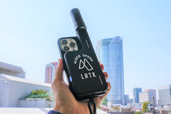
By incorporating this RTK technology into smartphones, the traditional heavy surveying equipment can now be replaced by just a smartphone. For example, by attaching the external RTK-GNSS receiver "LRTK" to an iPhone, the smartphone instantly transforms into a surveying device capable of centimeter-level accuracy.
There are numerous benefits to smartphone-based surveying. The first is portability. Since it only requires a smartphone and a small device that fits in your pocket, the burden of carrying equipment while moving along the tracks is greatly reduced. The second benefit is improved work efficiency through real-time positioning. The coordinates of the measured point are instantly displayed on the smartphone screen and can be saved to the cloud, allowing for on-site data verification and additional measurements. The third benefit is cost reduction compared to purchasing dedicated equipment. Since all that’s needed is to attach a device to an already-owned smartphone, it is far more cost-effective than the traditional GNSS surveying equipment that would typically cost several million yen. Additionally, while the positioning accuracy of the built-in GPS on the iPhone was within tens of centimeters, using RTK correction improves the positioning accuracy to centimeter-level precision.
In this way, smartphone + RTK surveying brings dual innovations of high precision and high efficiency to railway construction sites.
Use Cases for Smartphone RTK Surveying (Railway Construction)
By utilizing smartphone RTK, the maintenance management and construction surveying of railway infrastructure can become more efficient and smarter. Here, we will introduce specific use cases expected in railway construction.
-
Track Subsidence and Displacement Measurement: The subsidence and displacement of rails caused by train operations or ground movements can be measured regularly. Traditionally, this required time-consuming leveling surveys on the tracks, but with smartphone RTK, you can quickly capture the height and position of each point while walking along the tracks. For example, even when checking whether the tracks have shifted immediately after an earthquake, measurements can be taken over a large area in a short time, speeding up safety verification.
-
Positioning and Management of Catenary Poles, Signal Equipment, and Other Infrastructure: The locations of infrastructure such as catenary poles, signal lights, and level crossing equipment can be recorded with high precision and stored in a database. Photos taken with a smartphone can also have RTK-positioned coordinates tagged to them, allowing for accurate identification of the location of each photo during equipment inspections. This enables intuitive management of equipment locations on GIS maps, eliminating the need to cross-reference with drawings, as was necessary in the past.
-
Streamlining As-Built Surveying: RTK surveying is also effective for as-built surveying in railway civil engineering projects (verifying the shape and dimensions of structures after construction). By surveying the subgrade and embankment with smartphone RTK, the height and slope at each point can be instantly obtained. The data collected can be directly reflected in electronic delivery drawings and 3D models, reducing on-site manual records and later data entry tasks. Cloud integration allows for real-time data sharing between the office and the site, speeding up the creation of inspection documents.
-
Improved Safety and Simplified Operations: Smartphone RTK surveying also contributes to improved safety during work. For example, by reducing the time spent on surveying tasks next to the tracks, the exposure time to potential danger from passing trains is also decreased. Additionally, since surveying can be done by a single person, work can be carried out with minimal personnel, reducing the physical strain in extreme heat or cold conditions. In fact, companies that have adopted network-based RTK have reported, "It's extremely helpful to reduce the workload in extremely hot conditions." The intuitive operation via the dedicated app makes it easy for staff without specialized training to use the system, which also leads to a reduction in work errors.
Traditional Surveying Methods vs RTK Smartphone Surveying (In-Depth Comparison)
Let's compare traditional surveying methods using total stations and levels with the new surveying method using smartphones + RTK. By understanding the characteristics and challenges of each, the advantages of RTK construction surveying become clearer.
-
Number of Workers and Procedures: Traditionally, two or more surveying staff were required, following a step-by-step process starting with setting up reference points, performing traverse surveys, and conducting elevation measurements with a level. With RTK surveying, one person can perform observations independently and efficiently. Particularly with network-based RTK, there is no need to set up a base station, and surveying can begin immediately with just the rover (moving station). This greatly reduces setup time on-site.
-
Surveying Time and Range: With a total station, it is necessary to set up the equipment at each measurement point to read the direction and distance, and for large-scale surveys, it is not uncommon to have to move tripods or work over multiple days. In contrast, smartphone RTK surveying allows for continuous point acquisition while walking, dramatically shortening the work time. Furthermore, when measuring long sections over distances greater than 1km, total stations require careful error correction, but with RTK, stable accuracy can be maintained over a wide area, resulting in cost-effective outcomes, making it suitable for large-scale projects.
-
Positioning Accuracy: The accuracy of traditional methods is high, with relative accuracy in short distances reaching the millimeter range. However, for positioning in a public coordinate system, linking to reference points and complex calculations were required. With RTK surveying, coordinates in the global geodetic system can be obtained at centimeter-level precision from the start, making it possible to use the data directly in design drawings or GIS without the need for coordinate transformation. However, as a unique weakness of GNSS, it is said that the accuracy in the vertical direction has about twice the error of the horizontal plane, and strict height measurements are still sometimes supplemented with a level. Nevertheless, the advantages of high-precision positioning in the horizontal plane and improved work efficiency significantly boost the overall productivity of surveying.
-
Data Utilization and Integration: In traditional surveying, there was the labor-intensive process of recording data on paper at the site and then digitizing it in the office. With digital surveying using RTK, the collected data is instantly digitized and can be uploaded to the cloud. For example, with LRTK, positioning data is automatically plotted on the cloud map, and photos and point cloud data can be instantly shared with stakeholders. This speeds up the feedback of surveying results, enabling timely integration into design and construction, as well as as-built management. It also has high compatibility with CAD and BIM, enabling seamless digital integration from surveying to design and construction management.
The Benefits of LRTK Implementation and the Future It Brings to the Field
As mentioned above, RTK surveying has a significant impact on construction surveying in general, and among them, Lefixia's "LRTK" is an attention-grabbing device that makes smartphone surveying more accessible. Let's take a look at the benefits that can be gained from implementing LRTK.
-
Labor Savings and Speeding Up Surveying Tasks: With LRTK, surveying tasks that previously required two people can now be completed by just one. For example, tasks that used to involve a total station and staff making multiple trips can now be completed with just one round-trip using a smartphone and LRTK. Since both movement and observation can be performed simultaneously, even long-distance surveying along railway tracks can be completed in a significantly shorter time. On-site, it has received high praise for being "easy and fast," and it has also helped reduce the physical strain of working in extreme heat or cold.
-
Cost Reduction and Productivity Improvement: LRTK leverages existing smartphones and is designed to be very affordable. Instead of purchasing multiple expensive surveying devices, it is realistic to equip each employee with a smartphone equipped with LRTK. Once every worker has their own smartphone surveying device, overall productivity on-site will improve dramatically. In fact, LRTK has been developed as a "pocket-sized universal surveying device," weighing just 125g and 13mm thick, making it easy to carry at all times. It can be quickly pulled out when needed to perform surveying and recording, and then instantly shared to the cloud, enabling tasks that were previously handled by surveying specialists to be carried out autonomously by individual workers.
-
The Future of Surveying with Smartphones: At first glance, surveying with smartphones may seem easy, but behind it lies the cutting-edge technology of satellite positioning and cloud computing. LRTK supports next-generation smart surveying, including layout assistance using AR technology and integration with photo point clouds, strongly driving the digital transformation of construction sites. Not only in railway construction but across the entire construction industry, the era where "everyone can perform surveying with a smartphone in hand" may soon be upon us. What once relied on the experience and intuition of skilled technicians is now shifting towards construction management based on quantitative data from RTK. Early adoption of accessible and high-precision tools like LRTK will directly contribute to strengthening future competitiveness.
Introduction to LRTK
If you're interested in smartphone RTK surveying, be sure to check out the official LRTK website. The official website provides useful information, including product specifications, case studies, and comparison materials with other RTK devices to help in your evaluation. Additionally, free material requests are available, allowing you to obtain detailed catalogs and technical documents for internal review. If you have concerns about actual implementation, you can resolve them by utilizing the demo or support services provided by the manufacturer. Taking the first step to gather information is the beginning of bringing the new technology of smartphone surveying to your site.
RTK technology is transforming railway construction surveying to be safer and more efficient. By utilizing its latest solution, LRTK, we encourage you to implement a smart surveying workflow on your site.
Railway construction surveying is undergoing a significant transformation with the advent of smartphone + RTK technology. This technology accelerates the surveying of tracks and equipment with high-precision positioning, enabling safe and reliable work even amid labor shortages. It is expected to become increasingly widespread in the construction industry. The advantages of reduced work time and enhanced data integration, compared to traditional methods, are clear, and it is anticipated to be a key tool for advancing site digital transformation (DX).
With the introduction of LRTK, why not challenge the traditional belief that surveying is difficult and dangerous, and instead transform it into a simple and smart task? By actively adopting the latest technology, you can support the safety and sustainability of railway infrastructure, while also improving productivity and strengthening competitiveness for your company. Experience the future of surveying with smartphones and take this opportunity to witness the change firsthand.
Significantly Improving Surveying Accuracy and Work Efficiency on Site with LRTK
The LRTK series achieves high-precision GNSS positioning in the fields of construction, civil engineering, and surveying, enabling significant reductions in work time and substantial improvements in productivity. It is also compatible with i-Construction, promoted by the Ministry of Land, Infrastructure, Transport, and Tourism, making it an ideal solution for advancing digitalization in the construction industry.
For more details about LRTK, please visit the links below:
-
What is LRTK|Official LRTK Website
-
LRTK Series|Device List Page
-
Case Studies|Applications on Construction Sites
For any questions regarding the product, quotations, or consultations about implementation, feel free to contact us through the inquiry form. Let LRTK take your construction site to the next stage.