A Must-See for General Contractors!
Achieve High-Precision Surveying with LRTK Phone + iPhone
This article takes an average of 2 minutes and 30 seconds to read
Published March 14, 2025
In the construction industry, driven by the need to address labor shortages and improve productivity, the wave of DX (digital transformation) is also reaching the surveying sector. While work with total stations and existing GNSS surveying equipment offers high precision, the equipment is expensive and requires specialized technicians, presenting challenges for large-scale surveying and the immediate use of data. This has led to the rise of a new "smartphone surveying" method, which combines smartphones and RTK technology.
For example, by combining an iPhone with a dedicated device, we have entered an era where anyone can achieve centimeter-level high-precision positioning on-site. In fact, the pocket-sized universal surveying tool "LRTK Phone," developed by a Tokyo-based startup, has created a quiet boom among on-site technicians. By simply attaching a super-compact RTK-GNSS receiver to an iPhone/iPad, it enables centimeter-level positioning in the global coordinate system, point cloud measurements, layout marking, and AR (augmented reality). Furthermore, surveying data can be instantly shared via the cloud, and the price is very reasonable compared to traditional equipment, making it highly expected that implementing one device per person will greatly improve on-site productivity.
In this article, we will explain the benefits and usage of the high-precision RTK surveying solution provided by the "LRTK Phone + iPhone" on construction sites.
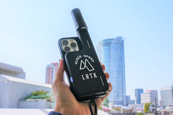
What is LRTK Phone? High-Precision RTK Surveying Achieved with a Smartphone
The LRTK Phone is an ultra-compact RTK-GNSS receiver that attaches to an iPhone for use. By attaching it to an iPhone or iPad through a dedicated smartphone case (or magnetic attachment), the smartphone transforms into a centimeter-level surveying device. The device itself weighs only about 125g and is 13mm thick, with a built-in battery that allows for approximately 8 hours of continuous use on a single charge.
Communication is established via Bluetooth, so no troublesome cables are required, and the device is also compatible with Android devices through the included magnetic ring.
The LRTK Phone is a high-performance receiver that supports multi-GNSS (GPS/GLONASS/Michibiki (QZSS)/Galileo/BeiDou, etc.) and is compatible with L1/L2/L5 three-frequency systems. By receiving correction data via network-based RTK (Ntrip), it achieves positioning accuracy of approximately ±1-2cm horizontally and ±2-3cm vertically.
Additionally, the LRTK Phone is compatible with Japan's quasi-zenith satellite system "Michibiki," which provides a centimeter-level positioning augmentation service (CLAS). This enables high-precision positioning using satellite correction signals even in areas with no mobile coverage, such as mountainous regions or tunnel construction sites.
The introduction of this out-of-coverage model responds to requests from civil engineering and infrastructure management sites, where mobile coverage is often limited. In fact, during the Noto Peninsula earthquake in January 2023, LRTK Phone was used for photo surveying in out-of-coverage areas, and it was highly praised with the comment, "We're really glad we had it."
By using the LRTK app, designed specifically for the LRTK Phone, not only can positioning functions be utilized, but a wide range of surveying and measurement needs on-site can also be met.
The applications of LRTK include not only single-point coordinate measurements but also point cloud data measurement in combination with the iPhone’s LiDAR, area and volume calculations for as-built checks, layout (positioning) and guidance support, as well as photo capture and AR simulation using design 3D data. The measured data is automatically synchronized to the cloud, allowing for real-time information sharing with the office, even from remote locations.
For example, automatic alignment of point clouds uploaded to the cloud with design models allows all relevant parties to instantly check and utilize the latest on-site data, which is another key feature.
With just one smartphone + LRTK, surveying tasks that previously required separate equipment and software can now be handled by a single device. This was developed as "an on-site tool that can be carried in a pocket and used immediately when needed," with the idea of providing one device per person.
The pricing is also more affordable compared to traditional surveying equipment, and subscription plans are available to reduce initial costs. It is truly an optimized smartphone surveying device for the construction industry.
Real-World Surveying Examples Using LRTK Phone
The LRTK Phone is used in various scenarios on civil engineering and construction sites. Here, we will introduce some representative applications and their benefits.
Simplification and Accuracy Improvement of Benchmark Surveying
Traditionally, setting up and surveying benchmarks (known points) on construction sites required precise line-of-sight with a total station or long GNSS observation times. With the LRTK Phone, surveying can begin immediately upon arrival at the site, and centimeter-level positioning can be achieved within just a few minutes. For example, by fixing the LRTK Phone on a tripod near a known electronic benchmark and using the app’s averaging function, high-precision benchmark coordinates can be obtained with a short observation time. The accuracy is about 12mm horizontally for standalone positioning, but it has been reported that averaging for about one minute improves the horizontal error to 8mm.
In this way, being able to establish benchmarks easily and accurately significantly shortens the startup time for surveying and enables subsequent work to proceed quickly. Once the benchmark is set, the rest of the site can be surveyed using LRTK, eliminating the need to carry heavy equipment and repeatedly set it up.
Streamlining and Real-Time As-Built Management
The LRTK Phone is highly effective for as-built management in civil engineering projects (verifying the shape of structures after construction). When calculating the volume of embankments or excavations, it was previously necessary to carefully survey the existing conditions and process the data. With LRTK, simply scanning the surroundings with the iPhone’s LiDAR scanner immediately generates point clouds (3D surveying data), and accurate position coordinates are assigned to each point, enabling volume calculations for embankments on the spot. The measurement results are instantly shared with the office via the cloud, allowing construction managers to check and verify as-built data in real-time, even from the office.
If there is any deficiency or excess, feedback can be provided immediately to prevent rework. The process that previously took several days—surveying → drawing → quantity calculation—can now be completed within the same day using LRTK Phone, offering benefits in both shortening the project timeline and ensuring quality. Additionally, by uploading design drawings or BIM/CIM data to LRTK Cloud, it is possible to verify on-site whether construction is proceeding according to the design by automatically overlaying the acquired point clouds. This immediate feedback and visualization make as-built management faster and more reliable.
Application in Infrastructure Inspection and Maintenance
Smartphone RTK surveying plays a significant role in infrastructure inspection and maintenance tasks, such as those for highways and railways. Traditionally, recording the location of cracks in bridges or surveying damage after a disaster required high-precision equipment and manual record-keeping. With LRTK Phone, both on-site investigation and documentation can be completed simultaneously, improving efficiency. For example, when an inspector takes a photo with the iPhone, the coordinates (latitude, longitude, height) of the photo’s location are automatically captured with centimeter-level accuracy, and the orientation (direction) of the photo is also recorded. The date, time, and notes are added and saved to the cloud, allowing for easy access to photos and their location/direction on a map from the office. Re-photographing the exact same location later to compare changes over time is also straightforward.
In fact, during the Noto Peninsula earthquake, despite being out of mobile coverage, the LRTK Phone’s out-of-coverage model was used for photo measurement and map sharing of the disaster site, contributing to a quick understanding of the situation. Similarly, in the case of a highway slope collapse, it is possible to use the object positioning feature from a safe distance, avoiding entry into dangerous slopes, and by placing a virtual AR stake, the repair location can be indicated.
In this way, by utilizing LRTK, on-site work in infrastructure maintenance becomes dramatically more efficient, and the accuracy and consistency of recorded data are also improved.
Basic Flow of Smartphone RTK Surveying
-
Setup: On-site, attach the LRTK Phone to the smartphone (such as an iPhone) and launch the dedicated app. If necessary, perform initial positioning at a reference point and establish centimeter-level position corrections using RTK correction data (via network or CLAS reception).
-
Surveying: Start positioning from the app at the point to be measured. In single-point measurement mode, record coordinates, or in continuous positioning mode, scan movement paths or surfaces.
When taking a photo, it is automatically saved with location and orientation information. If needed, load the design model and perform comparisons with the current conditions using AR display or execute virtual stake placement. -
Data Sharing: Measurement results (point coordinate data, point cloud models, photos, etc.) are synchronized to the cloud immediately after they are taken. On the office side, the shared data is visualized on maps or in 3D, allowing for progress verification and additional instructions from remote locations.
-
Utilizing Results: On-site, immediate as-built verification and corrections can be made, while in the office, drawing creation and report preparation can proceed based on the collected data. The high-precision data accumulated on the cloud is also useful for the subsequent construction management and infrastructure maintenance PDCA cycles.
Real-World Use Cases of LRTK
So, how is LRTK being used on-site in practice? Currently, it is being introduced across a wide range of fields, from civil engineering construction to infrastructure maintenance. One example is a mid-sized general contractor that adopted the LRTK Phone for managing a road improvement project, allowing them to conduct both surveying and as-built verification—tasks that were previously done separately—simultaneously. The site manager uses an iPad with the LRTK device to perform point cloud scanning of the daily as-built work and immediately calculates quantities in the cloud to track construction progress, with daily report generation also automated. Additionally, for highway tunnel inspections, LRTK is used to eliminate the need for workers to set up equipment in confined spaces, enabling them to measure coordinates and record photos of the structure from a safe distance.
Furthermore, the use of LRTK's AR functionality has been increasing in practice. For example, in river embankment renovation work, 3D scans of the site were conducted with LRTK before construction began, and the design 3D model was overlaid on the point cloud data in the cloud for verification. On-site, the virtual embankment model and the planned construction areas perfectly matched, as seen through the tablet screen, allowing all stakeholders to share the envisioned outcome. What was once difficult to convey with paper drawings or 2D photos—the completed vision—was intuitively shared through AR projection without positional discrepancies, making agreement formation with the client and final adjustments to the construction plan smoother.
There are countless other examples, but one common factor is that the speed of the "on-site surveying/measurement → data sharing → decision-making" process has dramatically increased. Tasks that were traditionally outsourced or handled by specialized surveying departments are now being completed in real-time by on-site personnel. This is not just about efficiency; it enables agile site management where decisions regarding construction and maintenance can be made in response to changes occurring on-site. Companies that have adopted this technology early on have expressed sentiments such as, "We can never go back to the old way," and "The way we work on-site has dramatically changed," underscoring how smartphone RTK surveying is becoming the new standard in the construction industry.
Introduction to LRTK
If you are interested in LRTK, which makes high-precision positioning easily accessible, we encourage you to consider requesting free materials. We offer documents with detailed specifications of the LRTK Phone, case studies, comparison data with other RTK devices, and other information that will assist in decision-making.
The combination of the smartphone and RTK-GNSS, LRTK Phone + iPhone, is set to bring revolutionary changes to the surveying style in the construction industry.
What was once a high-precision surveying process requiring specialized equipment and skills is now something that anyone can easily perform, making on-site digital transformation (DX) a reality. By drastically improving the immediacy and efficiency of surveying, construction planning, quality control, and infrastructure maintenance accuracy also improve, directly contributing to overall productivity increases and cost reductions for the entire project. As the construction industry continues to advance toward smarter and more digital solutions, smartphone-based RTK surveying will become an indispensable tool.
The benefits of introducing LRTK Phone, which is changing the norms on-site, are immeasurable. Take this opportunity to experience the latest smartphone surveying technology and stay ahead of the curve in next-generation surveying standards. The significant benefits gained on-site will undoubtedly bring great value to your business.
Significantly Improving Surveying Accuracy and Work Efficiency on Site with LRTK
The LRTK series achieves high-precision GNSS positioning in the fields of construction, civil engineering, and surveying, enabling significant reductions in work time and substantial improvements in productivity. It is also compatible with i-Construction, promoted by the Ministry of Land, Infrastructure, Transport, and Tourism, making it an ideal solution for advancing digitalization in the construction industry.
For more details about LRTK, please visit the links below:
-
What is LRTK|Official LRTK Website
-
LRTK Series|Device List Page
-
Case Studies|Applications on Construction Sites
For any questions regarding the product, quotations, or consultations about implementation, feel free to contact us through the inquiry form. Let LRTK take your construction site to the next stage.