Towards an Era of One RTK per Person:
Changing the Common Practices of Civil Engineering Surveying with iPhone and LRTK
This article takes an average of 2 minutes and 30 seconds to read
Published March 14, 2025
In recent years, the construction and civil engineering industries have been facing significant challenges such as a severe labor shortage and the need to adapt to work style reforms. In particular, in the surveying field, the aging of skilled technicians and the lack of successors have become prominent issues, and there has been little technological progress for over 50 years. Traditional surveying work required specialized knowledge and could not be done by a single person; it was essential to have at least two people working together, which also led to long working hours.
Against this backdrop, there is a growing demand for digital transformation (Construction DX) across the entire industry, and the Ministry of Land, Infrastructure, Transport and Tourism is promoting the use of ICT and 3D surveying through initiatives such as "i-Construction." For example, the introduction of drone surveying has been proven to significantly shorten the number of workdays and reduce the required personnel, making it a technology that allows surveying tasks to be carried out by fewer people.
In this context, a new surveying style, "One RTK per person," is about to revolutionize the field. RTK (Real-Time Kinematic) positioning is a high-precision positioning technology based on GNSS (Global Navigation Satellite System) that enables centimeter-level positioning in real time.
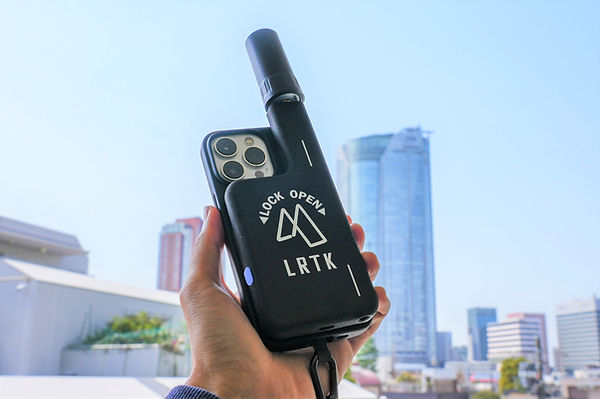
The era has arrived where RTK surveying, which traditionally required expensive specialized equipment and skilled operators, can now be performed by anyone with just a smartphone and a small receiver. For example, using a compact RTK receiver like the "LRTK Phone" that can be attached to an iPhone, the smartphone itself transforms into a high-precision surveying device. This technological innovation is set to greatly change the conventional practices in civil engineering surveying.
Comparison of Traditional Surveying Methods and One RTK per Person Surveying
In traditional construction surveying, it was common to use optical surveying instruments such as total stations (TS) and levels, or GNSS surveying equipment. These traditional methods have several challenges. First, there is the issue of manpower and time. With total station surveying, at least two people are required: a worker holding the prism at the survey point and a surveyor operating the equipment. Additionally, setting up the equipment and reading angles and distances took time.
In GNSS surveying as well, the installation of base stations and the development of survey plans required specialized knowledge, and in some cases, multiple people and expensive equipment were needed. Manual measurements and leveling surveys were even more time-consuming, and when including the recording of measurement results and the creation of drawings, they led to long working hours.
Furthermore, traditional surveying often relied on craftsmanship and became a task dependent on individual skills. Much of the work depended on the experience and intuition of veteran surveyors, which led to variations in surveying accuracy and efficiency from site to site. For example, in narrow sites or environments with many obstacles, traditional methods sometimes made surveying itself difficult. Additionally, human errors such as recording mistakes at survey points and calculation errors from manual computations were common.
On the other hand, surveying with one RTK per person solves all of the issues associated with traditional methods. As mentioned earlier, RTK surveying is a technology that provides real-time positioning accuracy of a few centimeters using satellite positioning, and in recent years, the convenience has drastically improved with the spread of network-based RTK and the domestic satellite "Michibiki" centimeter-level augmentation service (CLAS). Particularly with the combination of smartphones and compact RTK receivers, often referred to as smartphone surveying, high-precision positioning can now be achieved instantly, even with solo work. For example, by attaching the LRTK Phone to an iPhone, there is no need for complex base station setup or cable connections, and a single technician can survey while walking around the site. With traditional smartphone GPS, positioning accuracy might have been off by several meters, but with RTK, it can be improved to within a few centimeters.
As a result, surveying tasks that previously took a team of two people half a day can now be completed by one person in a shorter amount of time. In fact, it has been reported that the one-person-per-RTK system using an iPhone and LRTK has the potential to significantly improve productivity in on-site operations.
The Process of Smartphone RTK Surveying Using LRTK Phone
Now, let's take a look at the basic process of how RTK surveying is conducted using the LRTK Phone.
-
Device Preparation and Connection:
First, attach the LRTK Phone receiver to your smartphone, such as an iPhone. The LRTK Phone is an ultra-compact GNSS receiver integrated into a smartphone case, which connects wirelessly to the smartphone via Bluetooth or Wi-Fi. No complicated cable connections are required; simply power on the receiver and launch the dedicated app to complete the positioning setup. The receiver, which includes an antenna and battery, is small enough to fit in one hand and can be mounted on a monopod or tripod if needed. -
Obtaining RTK Correction Data:
To achieve high-precision positioning, GNSS correction data (RTK correction) is obtained. In sites where the smartphone can connect to the internet, correction data is received from private network-based RTK services or reference station VRS. In Japan, the system also supports CLAS (Centimeter-Level Augmentation Service) via Michibiki (Quasi-Zenith Satellite), allowing correction data to be obtained directly from satellites even in remote areas with no mobile signal. The LRTK Phone 4C off-network model can continue high-precision positioning via CLAS even in areas outside of communication coverage. With its support for a wide range of correction methods, the LRTK Phone's strength lies in its ability to perform stable RTK surveying in any site environment. -
Measuring Survey Points with the Surveying App:
Surveying begins using the dedicated app "LRTK" on the smartphone. The app offers both single-point positioning mode and continuous positioning mode. In single-point mode, the coordinates of any selected point can be recorded with a single tap. By simply pressing the button on the smartphone screen at the desired point, the latitude, longitude, and elevation are instantly obtained, eliminating the reading or transcription errors common in traditional methods. In continuous positioning mode, the position can be logged at a frequency of 10 points per second (10Hz), allowing the terrain profile to be recorded while moving. For example, by walking around a site and continuously recording boundary lines and terrain shapes, the trajectory can later be visualized as a map. -
Marking and Positioning (Layout):
The LRTK Phone can be used not only for measurement but also for marking positions on-site based on design drawings. Traditionally, surveyors would calculate angles and distances from coordinates on the drawing to perform staking or marking. With LRTK, design coordinates can be entered into the app, and by using the guidance feature, anyone can mark the designated position. The dedicated app displays the distance and direction from the current location to the set target (designated point) in real time. In a sense, the smartphone functions as both a surveying instrument and a navigation tool, providing guidance such as "How many meters to go" and "Which direction to turn." If necessary, the device can be mounted on a monopod, and by aligning the position and height, the marking can be completed. Without relying on complex calculations or the intuition of skilled professionals, the exact location of reference points or structural placement can be determined, enabling staff without surveying expertise to complete the layout work. -
As-Built Management and Photogrammetry:
Smartphone RTK is also highly effective for as-built management (as-built surveying) after construction. For example, the top height or center position of a structure after concrete pouring can be measured quickly by a single person. The measurement results are immediately saved as digital data, allowing on-site verification and instant judgment on whether any corrections are needed. Additionally, the LRTK app includes a photogrammetry feature. When taking photos of the site with the smartphone camera, the photo automatically records the high-precision location (latitude, longitude, elevation) and the camera's orientation. The recorded photos are placed on a map, and multiple photos can be combined to get an overview of the current situation. For instance, if photos taken before and after construction are stored with precise location data, comparing and verifying the as-built conditions becomes much easier. -
Point Cloud Scanning (3D Measurement):
By combining the LiDAR scanner included in iPhone 12 and later models, 3D point cloud measurement of terrain and structures is also possible. Using the "Terrain Scan" feature in the LRTK app, point cloud data can be obtained by simply holding the smartphone and scanning the target. Each point of the obtained point cloud is assigned high-precision coordinates via RTK/CLAS, enabling 3D surveying with accuracy comparable to traditional laser scanners, all with just the smartphone. This allows advanced measurements such as calculating the volume of excavation materials or measuring displacement of structures to be performed by a single person. -
Data Storage and Sharing (Cloud Integration):
Once the measurements are completed, the data is organized and shared. The location data, photos, and point clouds obtained through the LRTK app are saved directly on the smartphone, and with just one click, they can be uploaded to the dedicated cloud platform, "LRTK Cloud." The data uploaded to the cloud can be visualized and managed along with maps and models in a web browser. For example, by accumulating daily survey points in the cloud, automated as-built management reports (daily reports) can be generated, and real-time information sharing with stakeholders becomes possible. Survey data, which was previously managed individually on paper field notebooks or CAD drawings, is now centralized via the cloud, transforming it into a database that can be accessed immediately by those who need it.
This is the basic flow of smartphone RTK surveying using the LRTK Phone. As you can see, surveying tasks on-site have become much simpler, while still ensuring high accuracy. In the next chapter, we will look at specific scenarios to see how this technology can be applied in actual construction sites.
Scenes of RTK Technology Application in Construction Sites
The introduction of smartphone RTK surveying (LRTK Phone) is expected to improve efficiency and quality across various tasks on construction and civil engineering sites. Here, we will introduce some representative use cases.
-
Reference Point Surveying and Leveling Surveying:
Smartphone RTK is highly effective for tasks such as setting up temporary reference points at the start of construction and performing leveling measurements. Traditionally, these tasks were carried out by skilled surveyors using a transit or level, often taking half a day. With LRTK, they can be completed by one person in a short time. By determining the reference points on-site based on coordinates and elevation data from the design drawings, they can be instantly shared with other workers, improving the efficiency of subsequent tasks. For example, in road construction, quickly establishing the starting point and centerline reference points helps streamline the preparation process for construction. -
Marking (Positioning) Work:
Marking the placement of buildings and structures is a crucial process that determines construction accuracy. The advantage of smartphone RTK for marking is that anyone can mark the exact position accurately. Whether it's marking the reinforcement bar positions, anchor bolt installation locations, or the placement of road signs or light poles, any situation that requires precise placement can be addressed by reproducing the design coordinates on-site. By setting the target coordinates in the LRTK app, workers can simply follow the on-screen guidance on their smartphones to move and mark the locations. This eliminates the dependence on individual expertise in marking tasks and allows site work to continue even in the absence of surveying professionals. For management, the reduction in rework due to marking errors leads to shortened project timelines and cost savings. -
As-Built Management (As-Built Surveying):
Smartphone RTK is also useful for verifying as-built conditions after construction. For example, road surface elevations in paving work or the final ground elevation in land development can be measured accurately in a short amount of time, allowing real-time comparison with design values. By enabling more frequent checks of important structures, the level of quality control improves. As-built data accumulated in the cloud can be directly used for future inspections and can easily be submitted as proof along with photo data. If as-built surveying, which was previously outsourced to specialized companies, is internalized, it can also lead to cost savings on outsourcing fees. -
Safety Management and Maintenance:
In infrastructure maintenance sites, high-precision location data becomes a powerful tool. For example, in patrol inspections of highways or railways, LRTK can be used to photograph areas that need repair. Since photos taken with RTK positioning are tagged with accurate location coordinates, the damaged areas found during inspections can be accurately shared on a map. -
As a result, reports such as "Crack found near xx bridge" are managed as objective information linked to map data. In the future, it is possible to track the progression of deterioration over time in a digital twin space that accumulates inspection results. This use of smartphone RTK can be considered a form of digital transformation (DX) for infrastructure inspections, significantly improving the efficiency and accuracy of maintenance operations.
-
Digital Construction and Machine Guidance:
There is also potential for applying this technology to construction machinery. Currently, machine guidance technology exists where GNSS is installed on construction machinery to assist operators. If as-built data or design models obtained from smartphone RTK can be immediately fed back to the site, the instructions given to heavy equipment operators will become more accurate. For example, in excavation work, the surveyor can verify if the required excavation depth has been reached on-site and immediately communicate this to the operator. Additionally, by using AR functionality, high-precision location data plays a key role in the "digital construction" field, where BIM/CIM models are overlaid on a tablet screen during construction. The LRTK Phone already features the ability to recreate design data on-site via AR, and it is even possible to place virtual AR stakes on drawings or models. This enables flexible construction management, such as positioning virtual stakes in areas where it is difficult to physically place stakes. We can also expect further development into a new construction style that merges digital and real-world processes.
As mentioned above, the smartphone RTK technology, LRTK Phone, can be utilized in a wide range of scenarios, from surveying and construction management to maintenance. For site supervisors and construction managers, it becomes easier to check progress and as-built conditions themselves, reducing delays due to "waiting for surveying" and leading to improved overall productivity. For management, the introduction of DX tools helps overcome human resource limitations, enabling a system where multiple sites can be efficiently managed by a small team. Additionally, the accumulation of quality data leads to shared expertise, and enhanced explanatory materials for clients improve reliability, providing further benefits.
Benefits of Introducing LRTK Phone
Let’s review the main benefits gained by introducing the smartphone RTK device "LRTK Phone" to construction sites.
-
Reduction in Surveying Costs:
The most direct benefit is cost reduction. Traditionally, high-precision surveying required GNSS equipment worth several million yen and significant labor costs. The LRTK Phone is offered at a very reasonable price, significantly reducing initial investment. Additionally, if tasks that were previously outsourced to external surveying contractors can be internalized, it will lead to savings on outsourcing fees. Since a single worker can now handle surveying tasks, the efficiency of labor costs cannot be overlooked. For example, in cases where a surveyor was called in for small-scale surveying tasks, after introducing the LRTK, on-site staff can handle the work themselves. -
Ease of Operation and Quick Familiarization:
The LRTK Phone is operated through a smartphone app, eliminating the need for complex control panels or code input tasks typical of specialized equipment. The user interface is intuitive, designed to be easily used by both young and experienced workers, and anyone can perform basic surveying with just a short training session. This also contributes to improving the IT literacy of the entire on-site workforce. Surveying skills, which were once dependent on individual expertise, are now standardized, allowing the workload to be shared among all team members without being concentrated on specific technicians. Additionally, since it is smartphone-based, the hassle of transporting and setting up equipment on-site is reduced, and the flexibility to start surveying tasks immediately when needed is another attractive feature. -
Real-Time Data Sharing and Cloud Integration:
The data obtained with the LRTK Phone can be instantly shared via the cloud. This significantly reduces the time lag involved in taking information from the field, creating drawings, and preparing reports in the office. For example, if the results of an on-site survey are uploaded to the cloud first thing in the morning, office staff and clients can check the data in real time. Since all stakeholders can instantly access and utilize the latest surveying data, follow-up corrections and communication losses are minimized. The cloud stores surveying point coordinates, photos, and point cloud models, making it easy to compare with past data and perform statistical analysis. Additionally, there are export functions to CSV and PDF formats, which allows for output to traditional forms. The acceleration of such data integration offers a significant benefit from a DX (digital transformation) perspective. -
Improved Safety and Quality:
The ability to conduct surveying quickly and by oneself also enhances safety and quality management. For example, in road construction sites with high traffic volumes, surveying can be completed with minimal downtime, reducing the risk of exposure to hazards for workers. Additionally, high-precision surveying allows for the early detection and correction of construction errors or quality issues, ultimately improving the final quality. As the reliability of surveying results increases, the risks associated with additional work or handling claims are also reduced.
As mentioned above, the introduction of the LRTK Phone offers benefits in terms of cost, time, manpower, and quality. For small to medium-sized civil engineering contractors and regional construction companies, where there is a need to manage multiple sites with limited personnel, this "one RTK per person surveying" will be a powerful tool. Due to the convenience of using just a smartphone, its adoption on-site will be smooth, making it an ideal example of a DX tool's integration into the workplace.
An example of the screen for managing surveying data on LRTK Cloud. 3D point cloud data obtained with a smartphone is instantly displayed on the cloud, allowing for measurements of distance and coordinates, and it can be managed in association with on-site photos (top right). By utilizing the cloud, data can be shared in real time between the site and the office, streamlining report creation and progress tracking.
Significantly Improving Surveying Accuracy and Work Efficiency on Site with LRTK
The LRTK series enables high-precision GNSS positioning in the construction, civil engineering, and surveying fields, making it possible to significantly reduce work time and improve productivity. It is also compatible with i-Construction, promoted by the Ministry of Land, Infrastructure, Transport and Tourism, and is the ideal solution to promote the digitalization of the construction industry.
For more details about LRTK, please visit the following links:
If you have any questions about our products, requests for estimates, or inquiries regarding implementation, please feel free to contact us using the inquiry form below. Let LRTK help take your construction site to the next stage.