High-Precision RTK Positioning in the Palm of Your Hand:
Utilizing iPhones for the Civil Engineering and Construction Industry
This article takes an average of 2 minutes and 30 seconds to read
Published March 14, 2025
The Need for Surveying DX in the Construction Industry
In recent years, with the evolution of surveying technology, the wave of digital transformation (DX) has been sweeping across construction sites. With initiatives like i-Construction and construction DX promoted by the Ministry of Land, Infrastructure, Transport, and Tourism, the use of ICT on-site has become an unavoidable challenge. However, traditional surveying requires expensive equipment such as total stations and dedicated GNSS devices, and operating them demands specialized skills and experience. Surveying tasks themselves often involve multiple people and complicated procedures, creating a burden on the site. This backdrop has led to a growing demand for "easier and more precise surveying methods."
What is gaining attention is the new surveying style using smartphones + RTK technology. Particularly, the combination of an iPhone and a compact RTK device has led to the emergence of a solution that significantly simplifies surveying equipment while achieving centimeter-level positioning accuracy. This is ushering in an era where even those who are not surveying experts can obtain high-precision location data using the smartphones they are familiar with. This "smartphone surveying" holds great potential for improving surveying efficiency and driving DX in the civil engineering and construction industries.
RTK Positioning with iPhone – Turning Your Smartphone into a Surveying Device
RTK stands for "Real-Time Kinematic," a technology that enables much higher precision positioning than GPS. By reflecting correction data from a reference station in real-time, it cancels out the errors that are inevitable with standard GPS, achieving high-precision positioning at the centimeter level. While the positioning error of typical smartphone-built-in GPS is said to be around 5-10 meters, using RTK provides an extraordinary accuracy with an error of just a few centimeters.
However, traditionally, performing RTK surveying required high-performance GNSS receivers, base stations, and radio equipment, making it difficult to accomplish with just a smartphone.
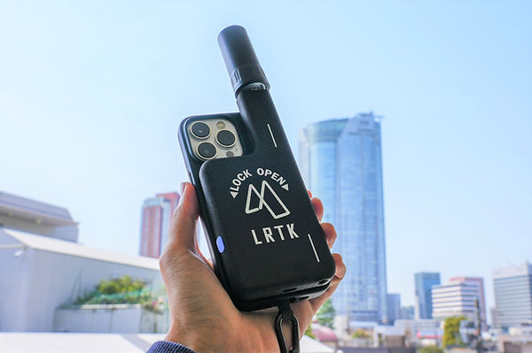
This is where the combination of the iPhone and an external RTK device comes in. By using the compact RTK receiver "LRTK Phone," which can be attached to the back of the iPhone, your handheld smartphone instantly transforms into a high-precision GNSS surveying device. For example, by attaching the LRTK Phone to the iPhone and using the dedicated app, real-time network-based RTK positioning becomes possible, allowing easy centimeter-level positioning and point surveying.
With precision comparable to traditional surveying equipment, you can determine your current location and complete benchmark coordinates and various measurements on-site with just a smartphone. Furthermore, the high-precision position data obtained is automatically saved and shared in the cloud, making it possible to collaborate in real-time between the site and the office.
So, why is the iPhone suitable for surveying in the construction industry? One reason is that the iPhone itself has an intuitive and user-friendly interface, making it easier for on-site staff to get accustomed to the operation. Unlike complex surveying equipment, anyone can start surveying simply by tapping the positioning start button on a smartphone app.
Additionally, the latest iPhone models (Pro series) come equipped with LiDAR sensors and high-performance cameras, allowing users to scan the surrounding 3D shapes or take high-resolution photos. By reinforcing positioning accuracy with the external RTK device, the iPhone’s LiDAR measurements can be used with centimeter-level precision, enabling even simple terrain surveys and 3D documentation of as-built conditions to be performed smoothly with a smartphone. Moreover, all photos taken are tagged with high-precision location coordinates, making it easy to plot and manage them on a map.
In this way, the combination of the palm-sized iPhone + RTK device is set to revolutionize the surveying style on construction sites.
Use Cases for RTK Surveying – The Expanding Possibilities of Smartphone Surveying on Construction Sites
When high-precision RTK positioning becomes easily accessible on a smartphone, various aspects of civil engineering and construction sites can benefit. Here, we will introduce some of the most impactful use cases.
Simplification and Accuracy Improvement of Benchmark Surveying
Benchmark surveying, which is essential in road construction and site preparation, becomes much easier with smartphone RTK. Traditionally, surveyors needed to use total stations or GNSS surveying equipment to obtain coordinates from known points. However, with iPhone + LRTK, you can immediately obtain high-precision coordinates of your current location as soon as you arrive on-site, allowing for the instant creation of temporary benchmark points.
For example, before setting up heavy machinery, walking around key areas of the construction site and measuring a few coordinates with a smartphone will make subsequent work smoother. Since benchmarks can be set with accuracy within a few centimeters, this significantly reduces the effort required for preliminary surveying work. The measurement results can be shared with the office via the cloud, enabling real-time creation of survey drawings. The ability for on-site staff to perform a certain level of benchmark surveying without relying on a specialized surveying team is truly groundbreaking.
Real-Time As-Built Management
As-built management for embankment, excavation, and paving work (verifying the shape and dimensions after construction) can also be streamlined in real-time with smartphone surveying. Traditionally, after construction, the surveying team would measure the site, create drawings, and then check the as-built conditions. This often led to delayed responses when rework was necessary. By utilizing iPhone + RTK, the construction supervisor can measure and verify the as-built conditions on-site.
For example, scanning the pavement right after it is completed with the iPhone's LiDAR and recording the data as a point cloud with high-precision coordinates allows for an instant check of thickness and slope variations. Similarly, for excavation work, the depth and slope of the dug trench can be measured with the smartphone, enabling real-time verification of whether it aligns with the design. The measurement data is immediately uploaded to the cloud, allowing it to be shared with office technicians, so as-built checks and instructions can be made remotely. This leads to reduced rework and improved accuracy in quality control. When as-built management can be completed with just a smartphone, it will contribute to speeding up the entire construction management cycle.
Application in Infrastructure Inspection and Maintenance
High-precision smartphone surveying is also highly useful in the field of infrastructure inspection and maintenance. When conducting patrol inspections of highways, railway facilities, bridges, dams, and other structures, carrying an iPhone + LRTK makes it easy to record accurate location data for areas of concern. For example, if cracks in the road or changes in the slope are discovered, simply taking a photo with the iPhone adds location data such as latitude, longitude, and elevation at centimeter-level accuracy to the image.
This allows for precise identification of the "exact location of the issue," which is useful when planning repairs. In railway track inspections, if track distortions or equipment anomalies are recorded with a smartphone, there is no risk of location ambiguity due to GPS errors.
Furthermore, smartphone RTK is also valuable during disaster damage assessments. Even in mountainous areas or disaster-stricken regions with no mobile coverage, LRTK devices are compatible with the CLAS correction signals provided by Japan's quasi-zenith satellite "Michibiki," enabling high-precision positioning. In fact, during the 2023 Noto Peninsula earthquake, a civil engineering company was able to use an LRTK-equipped iPhone (out-of-coverage model) to document the damage on-site in detail.
In this way, even in many infrastructure sites where mobile signals are unavailable, accurate data collection is possible with satellite-based correction information, providing significant peace of mind. Additionally, since the acquired data can be visualized on a map, managing multiple inspection points from an overview becomes easier. As digital recording of inspection results and GIS integration progresses, it will lead to improved efficiency and advancement of the entire PDCA cycle in infrastructure maintenance.
Comparison with Traditional Surveying Methods – TS & GNSS Surveying vs Smartphone RTK
What makes the new surveying method using smartphone + RTK superior compared to traditional methods? In this section, we will compare total station and traditional GNSS surveying with iPhone + LRTK surveying, and outline the differences.
-
Traditional Surveying Methods: Optical surveying using total stations (TS), or GNSS surveying (RTK method) using a base station and rover.
-
New Surveying Method: GNSS surveying using an iPhone combined with a compact RTK receiver (LRTK Phone).
Benefits of Introducing LRTK Phone – The Value of Smartphone Surveying
What specific benefits can be gained by introducing an iPhone and LRTK Phone on-site? Here, we will outline the implementation effects from several perspectives.
-
Labor Savings and Speeding Up Surveying Tasks: With intuitive smartphone operation, surveying can be performed, reducing the need for specialized staff and assistants that were previously required. The ability to perform continuous positioning with a single touch while moving significantly reduces work time, even on sites with a large number of measurement points. It's expected that feedback such as "A half-day survey was completed in one hour" will be common. There is also no time spent on transporting or setting up equipment.
-
Cost Reduction: It leads to savings in the cost of purchasing and maintaining expensive specialized surveying equipment, as well as the costs associated with outsourcing surveying tasks to external contractors. By utilizing smartphones that are already owned, the initial investment is kept low, and the savings in labor costs due to reduced work time cannot be overlooked. For small and medium-sized civil engineering companies, the ability to perform high-precision surveying in-house at a low cost is an attractive benefit.
-
Effective Use of Data and Improved Productivity: By immediately storing surveying results as digital data, subsequent workflows are streamlined. Real-time information sharing between the site and the office via the cloud eliminates data entry errors and delays in communication after surveying. The acquired point cloud data and photos can be directly used in construction management software or CAD drawing creation, reducing the effort required for report generation. In other words, surveying transitions from being "done and finished" to "measured and utilized," leading to overall productivity improvements on-site.
-
Preparing for the Future of Surveying with Smartphones: In the increasingly advancing construction DX, smartphone-based surveying and measurement could become the standard method. By introducing LRTK Phone early, you can stay ahead of future workflow transformations. The latest iPhones are improving in performance every year, and along with this, the accuracy and functionality of smartphone surveying will continue to improve. For example, the advanced use of combining AR technology with high-precision positioning data to overlay design models onto the site has already begun. Introducing smartphone surveying can be seen as a step toward preparing for the future construction sites.
As mentioned above, surveying with iPhone + LRTK is not just a technological introduction; it brings significant business benefits, such as "addressing labor shortages," "improving cost structures," and "creating added value through data utilization." For on-site personnel, it reduces work burdens, while for business owners, it directly contributes to increased productivity and strengthened competitiveness, making the benefits of implementation easily noticeable.
Significantly Improving Surveying Accuracy and Work Efficiency on Site with LRTK
The LRTK series achieves high-precision GNSS positioning in the fields of construction, civil engineering, and surveying, enabling significant reductions in work time and substantial improvements in productivity. It is also compatible with i-Construction, promoted by the Ministry of Land, Infrastructure, Transport, and Tourism, making it an ideal solution for advancing digitalization in the construction industry.
For more details about LRTK, please visit the links below:
-
What is LRTK|Official LRTK Website
-
LRTK Series|Device List Page
-
Case Studies|Applications on Construction Sites
For any questions regarding the product, quotations, or consultations about implementation, feel free to contact us through the inquiry form. Let LRTK take your construction site to the next stage.