Revolutionizing Construction Management with AR:
Real-Time Visualization of Progress on Civil Engineering Sites
This article takes an average of 2 minutes and 30 seconds to read
Published February 28, 2025
The use of AR (augmented reality) in the civil engineering industry is revolutionizing construction management. By simply using a smartphone or tablet, 3D design models and construction data can be overlaid onto the site, enabling real-time visualization of construction progress, reducing construction errors by cross-referencing design data, and facilitating smoother information sharing between clients and contractors—resulting in numerous benefits.
The attention towards civil AR technology, which supports Construction DX (Digital Transformation), is growing, from major general contractors to small civil engineering firms, surveying professionals, and infrastructure maintenance teams in sectors like railways and highways.
This article will discuss the innovations brought by AR technology to construction management in civil engineering and present concrete use cases.
Benefits of AR in Construction Management
Let’s explore the main benefits of utilizing AR technology on construction and civil engineering sites. From progress management and quality assurance to improving communication, AR provides extensive support for construction management.
Real-Time Visualization of Construction Progress
By using AR, design models and schedule information can be overlaid onto the current site conditions, allowing for an intuitive "visualization" of work progress. For example, by displaying the completed model in AR on the construction site, the progress can be easily understood at a glance, enabling immediate identification of any discrepancies from the plan. This allows for adjustments to the schedule and resource allocation as needed, making it easier to align the understanding of all stakeholders.
In fact, it has been reported that by overlaying the design drawings onto the actual building during construction, progress can be visually monitored, leading to quicker responses to design errors or construction defects. Real-time progress visualization is expected to contribute to reducing project timelines and costs.
Reducing Construction Errors through Verification with Design Data
By directly comparing the 3D design data displayed in AR on-site with the actual construction, discrepancies in surveying or construction errors can be detected and corrected in advance. Construction personnel can continuously compare the AR model with the actual structure as they work, ensuring that the project progresses with "design accuracy."
For example, in rebar installation, the placement plan can be overlaid in AR, allowing for immediate checks on the number and spacing of the rebar to ensure there are no errors. Locations of buried utilities and dimensions of structures, which are difficult to identify after completion, can also be confirmed in AR during construction, reducing the risk of rework. In fact, there have been reports of cases where overlaying design drawings during construction has enabled early correction of construction defects, leading to a reduction in rework and material waste.
In this way, strengthening quality control through AR directly contributes to improving site productivity.
Smooth Information Sharing Between Clients and Contractors
AR enables all stakeholders to share the site conditions and the completed design visualization, greatly improving the quality of communication. By overlaying a 3D model onto the real-world view via a tablet, clients, contractors, designers, and workers can all visualize the same completed project.
This allows aspects that are difficult to convey with drawings or words to be intuitively understood, helping to resolve any discrepancies in understanding. For large-scale projects, using AR models for online meetings allows for on-site evaluations from remote locations, significantly reducing the number of on-site visits and business trips.
Additionally, AR is effective for explaining the final design to residents and gaining their agreement. By projecting the full-scale model onto the site, it becomes easier to explain the project visually to local residents and clients, increasing their understanding and cooperation.
Thus, AR functions as an information-sharing platform between the site and the office, as well as between clients and contractors, facilitating smooth decision-making.
Specific Images and Use Cases of AR
Let’s explore how AR is being applied on civil engineering sites through specific scenarios. From general contractors to infrastructure maintenance and surveying tasks, we will introduce the roles AR plays at each type of site.
Use Case in General Contractors and Small Civil Engineering Firms
(Heavy Machinery Operators and Construction Managers)
From large general contractors to small local civil engineering firms, heavy machinery operators and site supervisors are beginning to utilize AR on construction sites. For example, in land development work, operators can overlay the design's completed terrain model on a tablet, allowing them to check the height and width of excavation and embankment in real time while working. This enables less experienced workers to proceed with construction along the design lines without relying on guesswork.
Construction managers can visualize the foundation layout and the positioning of structures using AR, allowing for accurate staking and installation even without the oversight of experienced workers. In actual road construction and bridge projects, there have been cases where overlaying a 3D model in AR on the site allowed work to be carried out with the same precision as the design.
Furthermore, as construction progresses, the layout of the site (such as temporary fences and machinery placement) changes. By displaying the latest layout plans in AR, the movement and positioning of heavy machinery and equipment can be properly maintained. As a result, not only is rework minimized, but safety management of heavy machinery operations (such as displaying no-entry zones in AR) is improved, enhancing both site efficiency and safety.
Use Case in Infrastructure Maintenance
(Visualization for Railway and Road Maintenance)
AR is also a powerful tool in infrastructure maintenance, including for railways, highways, and bridges. In maintenance, it was common to inspect the site while holding design drawings and past inspection records, but with AR, design plans and inspection information can be overlaid directly onto the structures in front of you. For example, during regular bridge inspections, AR can display the bridge’s design drawings and repair history, allowing workers to easily identify areas that need repair or inspection.
By marking the location of previously repaired cracks with AR markers, inspectors can quickly identify the exact location during re-inspection, preventing any oversights. In railway equipment maintenance, AR can display the routes of buried cables and internal layouts of signaling equipment like a see-through diagram, speeding up inspections and fault resolution.
Additionally, AR contributes to enhancing safety. By displaying warning signs or procedural instructions in the workers' field of view, AR can help prevent entry into hazardous areas and reduce human errors.
The use of AR in infrastructure maintenance improves both the efficiency of inspections and the creation of a safer working environment, contributing to the sustainable management of aging facilities.
Use Case for Surveying Professionals
(Improved Positioning Accuracy and Pre-Construction Plan Verification)
In surveying and pre-construction as-built checks, AR enables high-precision positioning and intuitive verification. Traditionally, to verify design models on-site, surveyors would need to establish reference points with surveying instruments and mark locations with stakes or chalk. Now, by using an AR system linked with RTK-GNSS, design models can be accurately displayed on-site without the need for manual coordinate alignment.
Surveyors can simply walk the site with a tablet and place virtual "stakes" or "string lines" at any given point, dramatically reducing the labor involved in setting out survey points and staking. For example, even in sloped areas or locations with obstacles, virtual AR stakes can be placed from a distance, allowing for precise positioning in areas where physical access is impossible. Additionally, it is possible to overlay the surveyed point-cloud data with the 3D design model to check if the design aligns with the actual terrain and structures, allowing for early verification of the design plan.
For example, a cloud service like LRTK automatically aligns point-cloud data of the current terrain with BIM/CIM design data, enabling designers to easily verify whether their envisioned structure can be correctly implemented on-site.
By utilizing AR + positioning technologies, the efficiency of surveying work is greatly enhanced, and the accuracy of construction plans is improved while preventing rework. For surveying professionals, AR is becoming a new-era tool that allows for immediate visualization and sharing of measurement data.
Introducing LRTK and Information Request
LRTK:
The Only Tool for Easy AR Use Without On-Site Coordinate Alignment
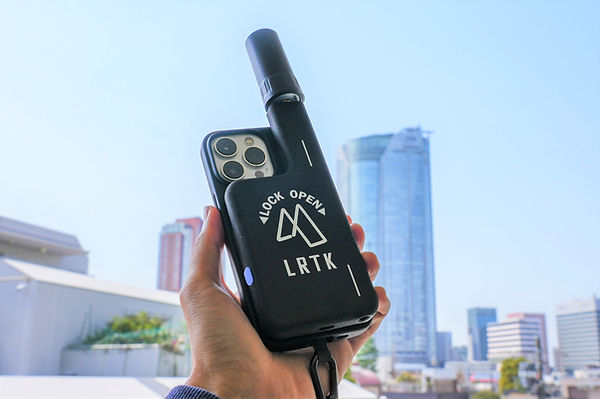
We introduce LRTK, a groundbreaking solution for AR construction management. LRTK is a state-of-the-art AR-enabled RTK-GNSS positioning tool provided by Lefixea, which can be used by simply attaching a compact antenna to an iPhone or iPad.
The key feature of LRTK is that coordinate alignment is not required on-site. Traditional AR systems required initial calibration to align markers with models on-site, but LRTK continuously tracks the position of the model and the real-world space using high-precision GNSS, ensuring stable and accurate AR projections without any positional drift.
Even when the user moves around, the model remains fixed and does not shift, allowing the BIM/CIM model to appear as if it’s “right there” in the real world. For example, even in areas covered by vegetation or where visibility is poor, AR allows the accurate positioning of desired signs or structures, directly improving efficiency on-site.
LRTK has already become a quiet trend in civil construction management, as it enables anyone to perform surveying and AR tasks with just a smartphone—one device per person. If you're interested in this tool that contributes to improving on-site productivity, please request free materials or visit the LRTK official website for more details.
By leveraging LRTK, you can bring a new level of visualization and efficiency to your projects, revolutionizing AR construction management.
Significantly Improve Surveying Accuracy and Work Efficiency on Site with LRTK
The LRTK series enables high-precision GNSS positioning in the fields of construction, civil engineering, and surveying, allowing for reduced work time and a significant increase in productivity. It is also compatible with the Ministry of Land, Infrastructure, Transport and Tourism's i-Construction initiative, making it an ideal solution to accelerate the digitalization of the construction industry.
For more details about LRTK, please visit the links below:
-
What is LRTK? | LRTK Official Website
-
LRTK Series | Device List Page
-
Case Studies | Examples of On-Site Applications
For product inquiries, quotes, or consultations regarding implementation, please feel free to contact us via this contact form. Let LRTK help take your site to the next stage of development.